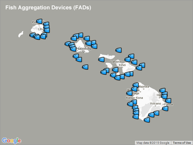
Fish Aggregation Devices (FADs) - Hawaii
Access & Use Information
Downloads & Resources
-
GeoServer
23 views
This URL provides access to this dataset via GeoServer, which offers multiple...
-
GeoExplorer
This URL provides a viewer for this dataset.
-
PacIOOS Voyager (Google Maps API)
This URL provides a viewer and/or data access for this dataset.
-
Related URL
This URL provides additional information related to this dataset.
-
Web Resource
-
Web Resourceapplication/vnd.lotus-organizer
36 views
-
Web Resource
-
Web Resource
-
Web Resourceapplication/vnd.lotus-organizer
36 views
-
OGC-WFSWFS
Open Geospatial Consortium Web Feature Service (WFS). Supported WFS versions...
-
Web Resource
-
Web Resourceapplication/vnd.lotus-organizer
36 views
-
OGC-WMSWMS
Open Geospatial Consortium Web Map Service (WMS). Supported WMS versions...
-
Web Resource
-
Web Resourceapplication/vnd.lotus-organizer
36 views
-
OGC-WMS-CWMS
24 views
Open Geospatial Consortium Web Map Service - Cached (WMS-C). Use of WMS-C is...
Dates
| Metadata Date | March 30, 2021 |
|---|---|
| Metadata Created Date | November 12, 2020 |
| Metadata Updated Date | June 3, 2023 |
| Reference Date(s) | January 25, 2016 (creation), January 25, 2016 (issued), January 25, 2016 (revision) |
| Frequency Of Update |
Metadata Source
- ISO-19139 ISO-19139 Metadata
Harvested from ioos
Graphic Preview

Additional Metadata
| Resource Type | Dataset |
|---|---|
| Metadata Date | March 30, 2021 |
| Metadata Created Date | November 12, 2020 |
| Metadata Updated Date | June 3, 2023 |
| Reference Date(s) | January 25, 2016 (creation), January 25, 2016 (issued), January 25, 2016 (revision) |
| Responsible Party | State of Hawaii Division of Aquatic Resources (DAR) (Point of Contact) |
| Contact Email | |
| Guid | hi_dar_all_fads |
| Access Constraints | |
| Bbox East Long | -154.778333333333 |
| Bbox North Lat | 22.33 |
| Bbox South Lat | 18.9558333333333 |
| Bbox West Long | -159.731666666667 |
| Coupled Resource | [{"title": [], "href": ["#DataIdentification"], "uuid": []}, {"title": [], "href": ["#DataIdentification"], "uuid": []}, {"title": [], "href": ["#DataIdentification"], "uuid": []}] |
| Frequency Of Update | |
| Graphic Preview Description | Sample image. |
| Graphic Preview File | http://pacioos.org/metadata/browse/hi_dar_all_fads.png |
| Harvest Object Id | bbaf87b5-845c-48f1-9e6a-424e85cfda64 |
| Harvest Source Id | 54e15a6e-6dde-4c9c-a8f0-345cc0dfccfb |
| Harvest Source Title | ioos |
| Licence | |
| Lineage | 2016-01-25T00:00:00Z OGC web services (WMS and WFS) enabled by PacIOOS via GeoServer. Original data from source provider may have been reformatted, reprojected, or adjusted in other ways to optimize these capabilities. |
| Metadata Language | eng |
| Metadata Type | geospatial |
| Old Spatial | {"type": "Polygon", "coordinates": [[[-159.731666666667, 18.9558333333333], [-154.778333333333, 18.9558333333333], [-154.778333333333, 22.33], [-159.731666666667, 22.33], [-159.731666666667, 18.9558333333333]]]} |
| Progress | |
| Spatial Data Service Type | Open Geospatial Consortium Web Feature Service (WFS) |
| Spatial Reference System | |
| Spatial Harvester | True |
Didn't find what you're looking for? Suggest a dataset here.

