
-
Federal
Sea Level Trends: Sea Level Variations of the United States Derived from National Water Level Observation Network Stations NGDA 48 recent views
National Oceanic and Atmospheric Administration, Department of Commerce —
Water level records are a combination of the fluctuations of the ocean and the vertical land motion at the location of the station. Monthly mean sea level (MSL)... -
Federal
Tides and Currents Map: an interactive map of all CO-OPS stations NGDA 27 recent views
National Oceanic and Atmospheric Administration, Department of Commerce —
This interactive map has many features designed to provide a quick and easy way to find a Center for Operational Oceanographic Products and Services (CO-OPS) station.... -
Federal
Willapa Bay, Washington Benthic Habitats 1995 Substrate
National Oceanic and Atmospheric Administration, Department of Commerce —
In June 1995, the Columbia River Estuary Study Taskforce (CREST) acquired 295 true color aerial photographs (1:12,000) of Willapa Bay, Washington, from the State of... -
Federal
High Tide Flooding Products from NOAA CO-OPS
National Oceanic and Atmospheric Administration, Department of Commerce —
High tide flooding is the overflow or excess accumulation of water that covers typically dry coastal land and occurs during high tides. As relative sea levels rise,... -
Federal
Shoreline Mapping Program of CAPE FLATTERY TO ABBEY ISLAND, WA, WA0401A NGDA
National Oceanic and Atmospheric Administration, Department of Commerce —
These data provide an accurate high-resolution shoreline compiled from imagery of CAPE FLATTERY TO ABBEY ISLAND, WA . This vector shoreline data is based on an office... -
Federal
Shoreline Mapping Program of WILLAPA BAY, WA, WA0401D NGDA
National Oceanic and Atmospheric Administration, Department of Commerce —
These data provide an accurate high-resolution shoreline compiled from imagery of WILLAPA BAY, WA . This vector shoreline data is based on an office interpretation of... -
Federal
Meteorological Data (including visibility)
National Oceanic and Atmospheric Administration, Department of Commerce —
The National Ocean Service (NOS) maintains a long-term database containing data from active and historic stations installed all over the United States and U.S.... -
Federal
Shoreline Data Rescue Project of Tacoma Harbor, Washington, CM-7311 NGDA
National Oceanic and Atmospheric Administration, Department of Commerce —
These data were automated to provide an accurate high-resolution historical shoreline of Tacoma Harbor, Washington suitable as a geographic information system (GIS)... -
Federal
Seagrass distribution off California
National Oceanic and Atmospheric Administration, Department of Commerce —
These data are a compilation of currently available seagrass GIS data sets for the west coast of the United States. These data have been compiled from seventeen... -
Federal
H04598: NOS Hydrographic Survey
National Oceanic and Atmospheric Administration, Department of Commerce —
The National Oceanic and Atmospheric Administration (NOAA) has the statutory mandate to collect hydrographic data in support of nautical chart compilation for safe... -
Federal
F00478: NOS Hydrographic Survey , St. Thomas Harbor, U.S. Virgin Islands, 2001-05-29
National Oceanic and Atmospheric Administration, Department of Commerce —
The National Oceanic and Atmospheric Administration (NOAA) has the statutory mandate to collect hydrographic data in support of nautical chart compilation for safe... -
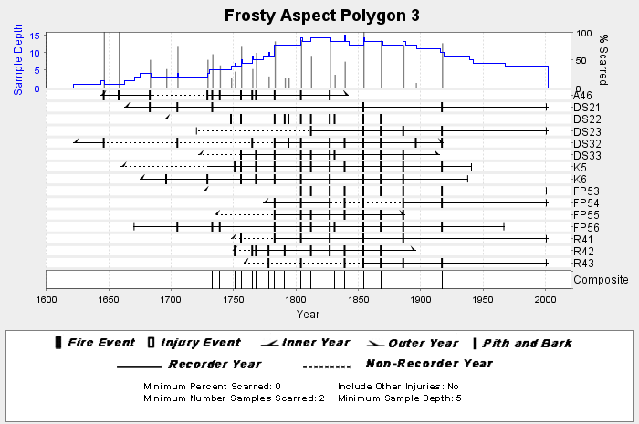
Federal
NOAA/WDS Paleoclimatology - Everett fire data from Frosty Aspect Polygon 3 - IMPD USFRS003
National Oceanic and Atmospheric Administration, Department of Commerce —
This archived Paleoclimatology Study is available from the NOAA National Centers for Environmental Information (NCEI), under the World Data Service (WDS) for... -
Federal
NOAA/WDS Paleoclimatology - Everett fire data from Twenty Mile Aspect Polygon 4 - IMPD USTWM004
National Oceanic and Atmospheric Administration, Department of Commerce —
This archived Paleoclimatology Study is available from the NOAA National Centers for Environmental Information (NCEI), under the World Data Service (WDS) for... -
Federal
NOAA/WDS Paleoclimatology - Everett fire data from Twenty Mile Aspect Polygon 8 - IMPD USTWM008
National Oceanic and Atmospheric Administration, Department of Commerce —
This archived Paleoclimatology Study is available from the NOAA National Centers for Environmental Information (NCEI), under the World Data Service (WDS) for... -
Federal
NOAA/WDS Paleoclimatology - Everett fire data from Frosty Aspect Polygon 6 - IMPD USFRS006
National Oceanic and Atmospheric Administration, Department of Commerce —
This archived Paleoclimatology Study is available from the NOAA National Centers for Environmental Information (NCEI), under the World Data Service (WDS) for... -
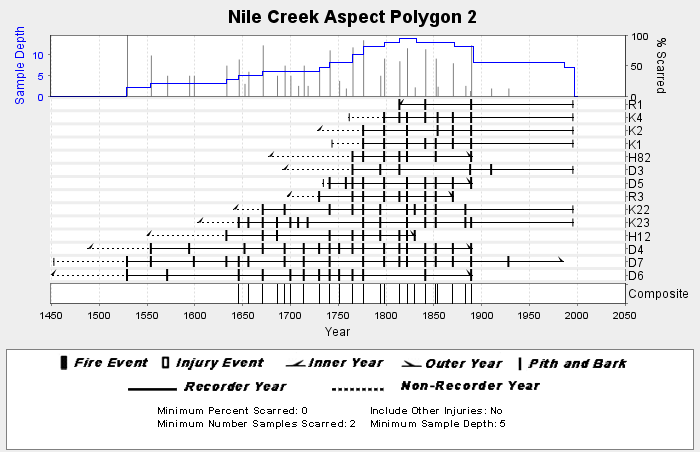
Federal
NOAA/WDS Paleoclimatology - Everett fire data from Nile Creek Aspect Polygon 2 - IMPD USNIL002
National Oceanic and Atmospheric Administration, Department of Commerce —
This archived Paleoclimatology Study is available from the NOAA National Centers for Environmental Information (NCEI), under the World Data Service (WDS) for... -
Federal
NOAA Water Levels for Coastal, Estuaries and Great Lakes regions
National Oceanic and Atmospheric Administration, Department of Commerce —
For over 200 years, NOAA's Center for Operational Oceanographic Products and Services (CO-OPS) and its predecessors have been managing a comprehensive system for... -
Federal
Outer Coast of Washington and Oregon 2014 ESI PARKS-MANAGED AREAS Polygons
National Oceanic and Atmospheric Administration, Department of Commerce —
This data set contains vector polygons depicting boundaries for management areas, marine sanctuaries, nature conservancies, National Estuarine Research Reserves... -
Federal
Shoreline Data Rescue Project of Ancortes and Vicinity, PH98 NGDA
National Oceanic and Atmospheric Administration, Department of Commerce —
These data were automated to provide an accurate high-resolution historical shoreline of Ancortes and Vicinity suitable as a geographic information system (GIS) data... -
Federal
Shoreline Mapping Program of NEAH BAY, WA, WA1301 NGDA
National Oceanic and Atmospheric Administration, Department of Commerce —
These data provide an accurate high-resolution shoreline compiled from imagery of NEAH BAY, WA . This vector shoreline data is based on an office interpretation of...

Official websites use .gov
A
.gov website belongs to an official government
organization in the United States.
Secure .gov websites use HTTPS
A
lock (
) or https:// means you’ve safely connected to
the .gov website. Share sensitive information only on official,
secure websites.