
-
Federal
Profiling Sensor to Map N2 Gas Production in OMZs
National Oceanic and Atmospheric Administration, Department of Commerce —
The newly developed Gas Tension Device (GTD) for this project was successfully tested. The new GTD was used to 150 m depth on the shipâs rosette CTD and step... -
Federal
Derelict Gear - Impacts of derelict fishing gear on marine fauna in Puget Sound and the Northwest Straits
National Oceanic and Atmospheric Administration, Department of Commerce —
Puget Sound and the Northwest Straits have experienced a long history of commercial fishing activity. Although much of this fishing activity no longer takes place,... -
Federal
Washington coast sablefish - Reproductive Life History Analysis of Sablefish Populations off the Washington and California Coasts
National Oceanic and Atmospheric Administration, Department of Commerce —
Sablefish (Anoplopoma fimbria) have a wide distribution along the Pacific coast, extending from Baja California to Alaska, the Bering Sea and through to the eastern... -
Federal
Pacific Coast Groundfish Individual Fishing Quota Database
National Oceanic and Atmospheric Administration, Department of Commerce —
On January 11, 2011, NOAA Fisheries implemented a new fishery management system for the West Coast Groundfish Trawl Catch Share Program as specified in the Magnuson-... -
Federal
SeaTurtleLeatherback_20120126
National Oceanic and Atmospheric Administration, Department of Commerce —
Critical habitat in the Caribbean Sea area includes the waters adjacent to Sandy Point, St. Croix from the 100 fathom curve shoreward to the level of mean high... -
Federal
SalmonSockeye_SnakeRiverESU_19931228_poly
National Oceanic and Atmospheric Administration, Department of Commerce —
Critical habitat includes the water, waterway bottom, and adjacent riparian zone of specified lakes. Adjacent riparian zones are defined as those areas within a... -
Federal
Pacific Coastal Salmon Recovery Fund
National Oceanic and Atmospheric Administration, Department of Commerce —
Congress established the Pacific Coastal Salmon Recovery Fund (PCSRF) to monitor the restoration and conservation of Pacific salmon and steelhead populations and... -
Federal
Recovery Action Mapping Tool
National Oceanic and Atmospheric Administration, Department of Commerce —
The Recovery Action Mapping Tool is a web map that allows users to visually interact with and query actions that were developed to recover species listed under the... -
Federal
SalmonCoho_LowerColumbiaRiverESU_20160224
National Oceanic and Atmospheric Administration, Department of Commerce —
Critical habitat includes the stream channels within the designated stream reaches, and includes a lateral extent as defined by the ordinary high-water line (33 CFR... -
Federal
SalmonChinook_PugetSoundESU_20050902_line
National Oceanic and Atmospheric Administration, Department of Commerce —
Critical habitat includes the stream channels within the designated stream reaches, and includes a lateral extent as defined by the ordinary high-water line (33 CFR... -
Federal
Steelhead_SnakeRiverBasinDPS_20050902
National Oceanic and Atmospheric Administration, Department of Commerce —
Critical habitat includes the stream channels within the designated stream reaches, and includes a lateral extent as defined by the ordinary high-water line (33 CFR... -
Federal
SalmonSockeye_OzetteLakeESU_20050902
National Oceanic and Atmospheric Administration, Department of Commerce —
Critical habitat includes the stream channels within the designated stream reaches, and includes a lateral extent as defined by the ordinary high-water line (33 CFR... -
Federal
West Coast Marine Mammal Stranding Network Contacts
National Oceanic and Atmospheric Administration, Department of Commerce —
The Marine Mammal Protection Act formalized a program to provide response to reports of strandings of marine mammals and unusual mortality events. This was done by... -
Federal
SalmonChinook_SnakeRiverspringsummerrunESU_19991025
National Oceanic and Atmospheric Administration, Department of Commerce —
Critical habitat includes the water, waterway bottom, and adjacent riparian zone of specified lakes and river reaches. Adjacent riparian zones are defined as those... -
Federal
SalmonChinook_UpperColumbiaRiverspringrunESU_20050902
National Oceanic and Atmospheric Administration, Department of Commerce —
Critical habitat includes the stream channels within the designated stream reaches, and includes a lateral extent as defined by the ordinary high-water line (33 CFR... -
Federal
Steelhead_UpperColumbiaRiverDPS_20050902
National Oceanic and Atmospheric Administration, Department of Commerce —
Critical habitat includes the stream channels within the designated stream reaches, and includes a lateral extent as defined by the ordinary high-water line (33 CFR... -
Federal
Steelhead_PugetSoundDPS_20160224
National Oceanic and Atmospheric Administration, Department of Commerce —
Critical habitat includes the stream channels within the designated stream reaches, and includes a lateral extent as defined by the ordinary high-water line (33 CFR... -
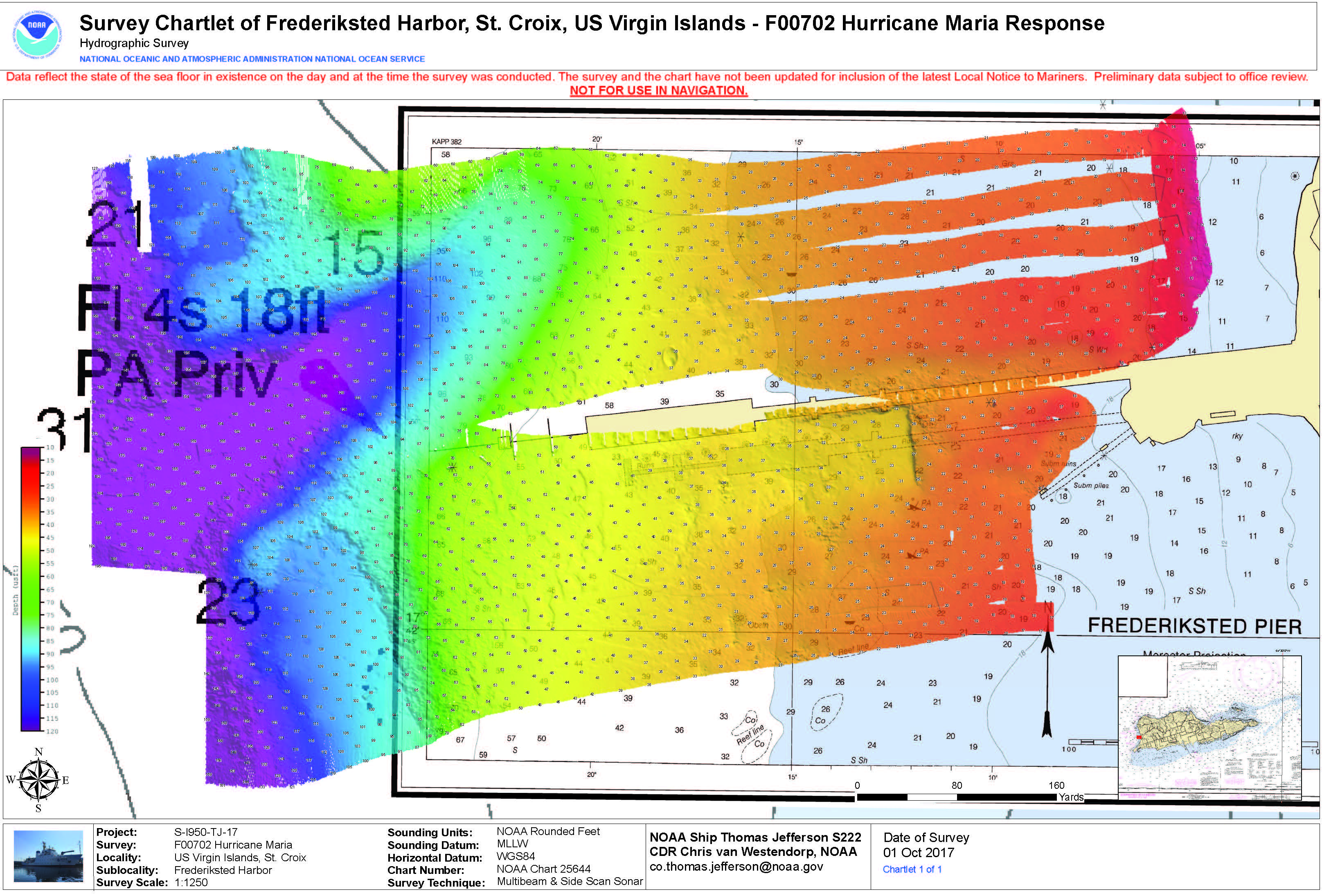
Federal
F00786: NOS Hydrographic Survey , 2017-10-01
National Oceanic and Atmospheric Administration, Department of Commerce —
The National Oceanic and Atmospheric Administration (NOAA) has the statutory mandate to collect hydrographic data in support of nautical chart compilation for safe... -
Federal
F00195: NOS Hydrographic Survey , 1964-04-14
National Oceanic and Atmospheric Administration, Department of Commerce —
The National Oceanic and Atmospheric Administration (NOAA) has the statutory mandate to collect hydrographic data in support of nautical chart compilation for safe... -
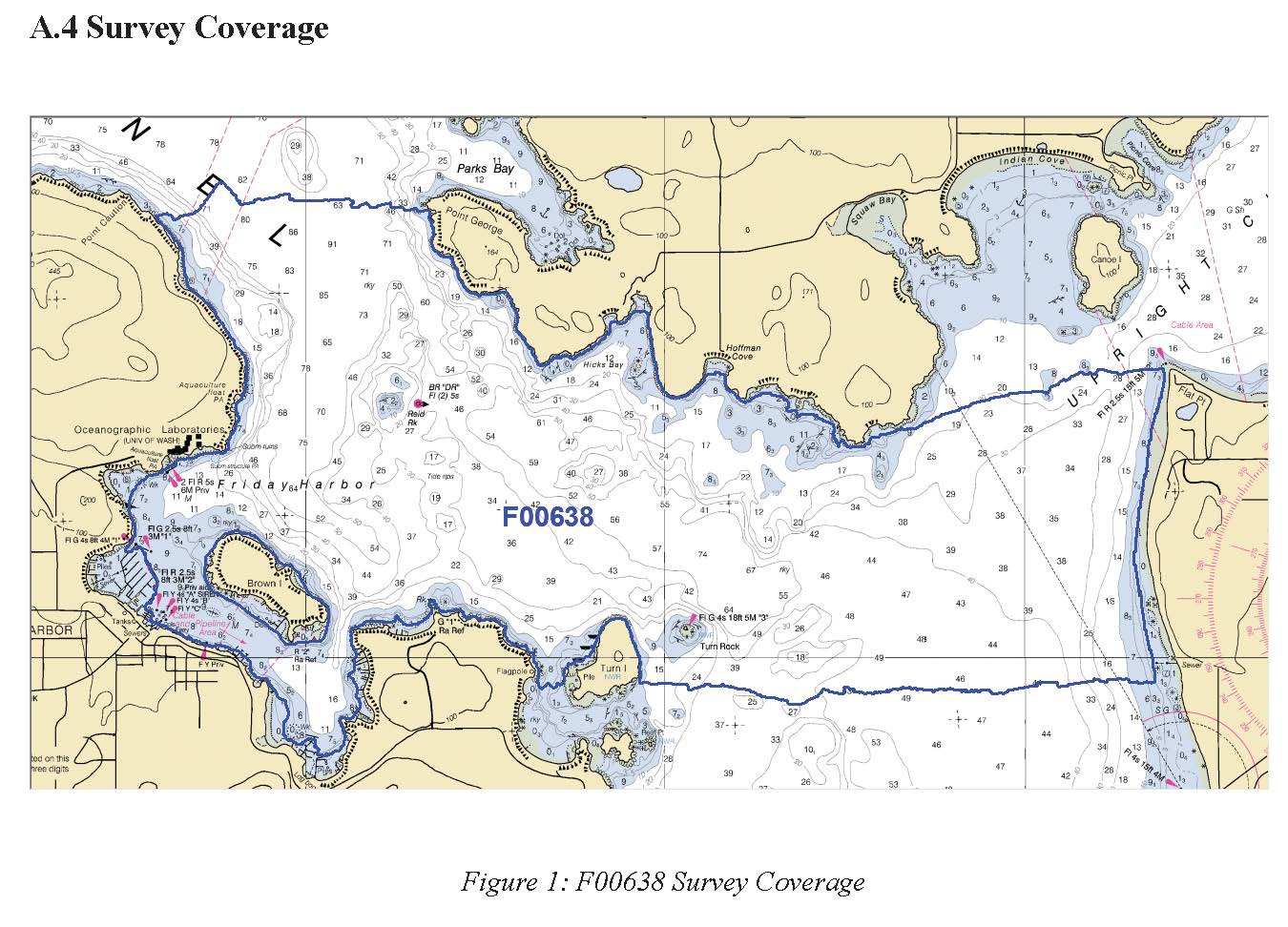
Federal
F00638: NOS Hydrographic Survey , 2014-04-21
National Oceanic and Atmospheric Administration, Department of Commerce —
The National Oceanic and Atmospheric Administration (NOAA) has the statutory mandate to collect hydrographic data in support of nautical chart compilation for safe...

Official websites use .gov
A
.gov website belongs to an official government
organization in the United States.
Secure .gov websites use HTTPS
A
lock (
) or https:// means you’ve safely connected to
the .gov website. Share sensitive information only on official,
secure websites.