
-
Federal
SalmonSockeye_OzetteLakeESU_20050902
National Oceanic and Atmospheric Administration, Department of Commerce —
Critical habitat includes the stream channels within the designated stream reaches, and includes a lateral extent as defined by the ordinary high-water line (33 CFR... -
Federal
Steelhead_MiddleColumbiaRiverDPS_20050902
National Oceanic and Atmospheric Administration, Department of Commerce —
Critical habitat includes the stream channels within the designated stream reaches, and includes a lateral extent as defined by the ordinary high-water line (33 CFR... -
Federal
Steelhead_UpperColumbiaRiverDPS_20050902
National Oceanic and Atmospheric Administration, Department of Commerce —
Critical habitat includes the stream channels within the designated stream reaches, and includes a lateral extent as defined by the ordinary high-water line (33 CFR... -
Federal
SalmonChum_HoodCanalsummerrunESU_20050902_poly
National Oceanic and Atmospheric Administration, Department of Commerce —
In nearshore marine areas, critical habitat includes areas contiguous with the shoreline from the line of extreme high water out to a depth no greater than 30 meters... -
Federal
SalmonChinook_SnakeRiverfallrunESU_19931228
National Oceanic and Atmospheric Administration, Department of Commerce —
Critical habitat includes the water, waterway bottom, and adjacent riparian zone of specified river reaches. Adjacent riparian zones are defined as those areas within... -
Federal
Olympic Coast National Marine Sanctuary Boundary (polygon)
National Oceanic and Atmospheric Administration, Department of Commerce —
The Office of National Marine Sanctuaries manages a system of sanctuaries and other managed areas around the country. The legal boundaries of These sanctuaries are... -
Federal
AFSC/RACE/GAP/McConnaughey:USBL Proof of Concept-1998-USBL data
National Oceanic and Atmospheric Administration, Department of Commerce —
The trials were conducted in Dabob Bay, Washington, in May 1998. The main objective of these trials was to determine an accurate and reliable system to track a... -
Federal
CO-OPS station 9449880: FRIDAY HARBOR, SAN JUAN CHANNEL 1-minute Raw Tsunami Water Level Data
National Oceanic and Atmospheric Administration, Department of Commerce —
CO-OPS has been involved with tsunami warning and mitigation since the Coast and Geodetic Survey started the Tsunami Warning System in 1948 to provide warnings to the... -
Federal
H10009: NOS Hydrographic Survey , St. Croix, Virgin Islands, 1982-04-23
National Oceanic and Atmospheric Administration, Department of Commerce —
The National Oceanic and Atmospheric Administration (NOAA) has the statutory mandate to collect hydrographic data in support of nautical chart compilation for safe... -
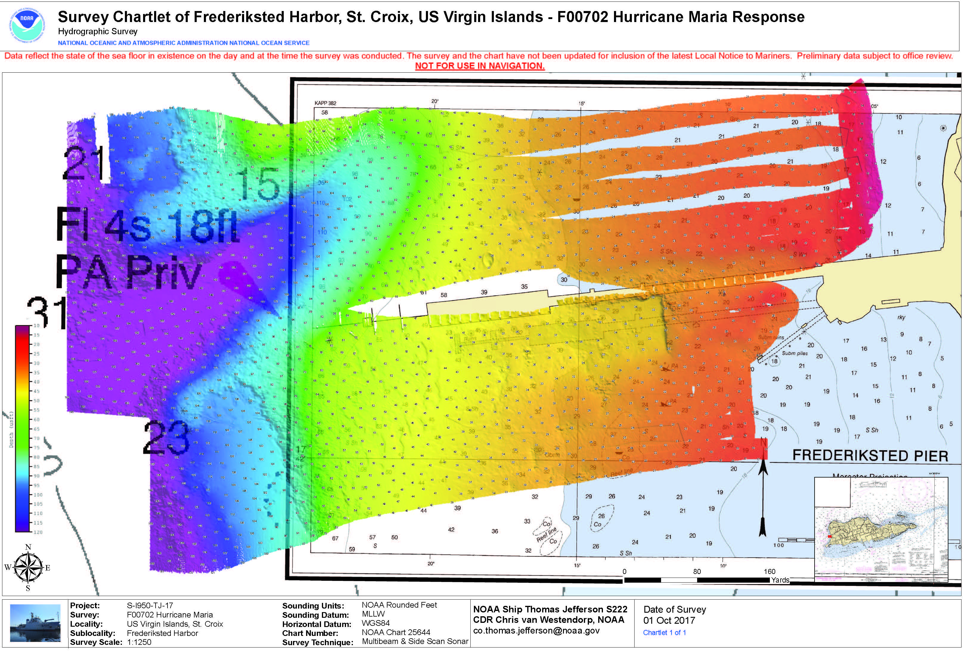
Federal
F00786: NOS Hydrographic Survey , 2017-10-01
National Oceanic and Atmospheric Administration, Department of Commerce —
The National Oceanic and Atmospheric Administration (NOAA) has the statutory mandate to collect hydrographic data in support of nautical chart compilation for safe... -
Federal
F00195: NOS Hydrographic Survey , 1964-04-14
National Oceanic and Atmospheric Administration, Department of Commerce —
The National Oceanic and Atmospheric Administration (NOAA) has the statutory mandate to collect hydrographic data in support of nautical chart compilation for safe... -
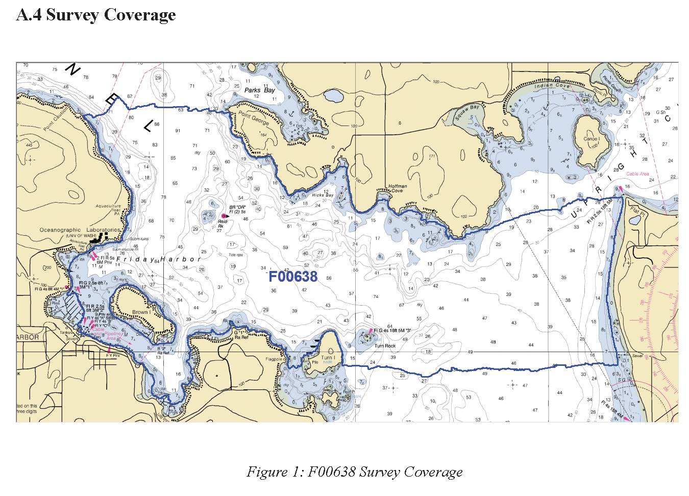
Federal
F00638: NOS Hydrographic Survey , 2014-04-21
National Oceanic and Atmospheric Administration, Department of Commerce —
The National Oceanic and Atmospheric Administration (NOAA) has the statutory mandate to collect hydrographic data in support of nautical chart compilation for safe... -
Federal
F00704: NOS Hydrographic Survey , 2017-10-04
National Oceanic and Atmospheric Administration, Department of Commerce —
The National Oceanic and Atmospheric Administration (NOAA) has the statutory mandate to collect hydrographic data in support of nautical chart compilation for safe... -
Federal
NOAA/WDS Paleoclimatology - Black - Lake Sammamish - PSME - ITRDB WA158
National Oceanic and Atmospheric Administration, Department of Commerce —
This archived Paleoclimatology Study is available from the NOAA National Centers for Environmental Information (NCEI), under the World Data Service (WDS) for... -
Federal
2014 NOAA NGS Ortho-rectified MLLW Near-Infrared Mosaic of Seattle and Lake Washington Ship Canal, WA
National Oceanic and Atmospheric Administration, Department of Commerce —
This data set contains ortho-rectified mosaic tiles, created as a product from the NOAA Integrated Ocean and Coastal Mapping (IOCM) initiative. The source imagery was... -
Federal
Shoreline Mapping Program of PUGET SOUND, EVERETT TO SPRING BEACH, WA, WA1403-CM-N NGDA
National Oceanic and Atmospheric Administration, Department of Commerce —
These data provide an accurate high-resolution shoreline compiled from imagery of PUGET SOUND, EVERETT TO SPRING BEACH, WA . This vector shoreline data is based on an... -
Federal
West Coast Marine Mammal Stranding Network Contacts Buffer
National Oceanic and Atmospheric Administration, Department of Commerce —
The Marine Mammal Protection Act formalized a program to provide response to reports of strandings of marine mammals and unusual mortality events. This was done by... -
Federal
West Coast Marine Mammal Stranding Network_Dead
National Oceanic and Atmospheric Administration, Department of Commerce —
The Marine Mammal Protection Act formalized a program to provide response to reports of strandings of marine mammals and unusual mortality events. This was done by... -
Federal
West Coast Marine Mammal Stranding Network Contacts
National Oceanic and Atmospheric Administration, Department of Commerce —
The Marine Mammal Protection Act formalized a program to provide response to reports of strandings of marine mammals and unusual mortality events. This was done by...

Official websites use .gov
A
.gov website belongs to an official government
organization in the United States.
Secure .gov websites use HTTPS
A
lock (
) or https:// means you’ve safely connected to
the .gov website. Share sensitive information only on official,
secure websites.
.jpg)