
-
Federal
2022 Cartographic Boundary File (KML), Current Block Group for Pennsylvania, 1:500,000
U.S. Census Bureau, Department of Commerce —
The 2022 cartographic boundary KMLs are simplified representations of selected geographic areas from the U.S. Census Bureau's Master Address File / Topologically... -
Federal
Research Report of Low Temperature Geothermal Play Fairway Analysis for the Appalachian Basin
Department of Energy —
This is a final report summarizing a one-year (2014-15) DOE funded Geothermal Play Fairway Analysis of the Low-Temperature resources of the Appalachian Basin of New... -
Federal
Natural Reservoir Analysis in Low-Temperature Geothermal Play Fairway Analysis for the Appalachian Basin
Department of Energy —
The files included in this submission contain all data pertinent to the methods and results of this task's output, which is a cohesive multi-state map of all known... -
Federal
GL_LAKE_ERIE_2022 ESI INVERT Polygons
National Oceanic and Atmospheric Administration, Department of Commerce —
These feature classes reside within the BIOLOGY Feature Data Set of the Lake Erie - 2022 ESI Geodatabase. It contains vector polygons representing invertebrate data... -
Federal
GL_LAKE_ERIE_2022 ESI HYDRO Polygons, Lines
National Oceanic and Atmospheric Administration, Department of Commerce —
The feature classes HYDROL and HYDROP contain vector lines and polygons representing the coastal shoreline and hydrography used in the creation of the Environmental... -
Federal
2022 NOAA NGS Ortho-rectified 4-band Mosaic of Philadelphia, Camden-Gloucester, Paulsboro, Pennsylvania
National Oceanic and Atmospheric Administration, Department of Commerce —
This data set contains 4-band ortho-rectified mosaic tiles, created as a product from the NOAA Integrated Ocean and Coastal Mapping (IOCM) initiative. The source... -
Federal
Shoreline Data Rescue Project of Delaware River, PA and NJ, PA1935A NGDA
National Oceanic and Atmospheric Administration, Department of Commerce —
These data were automated to provide an accurate high-resolution historical shoreline of Delaware River, PA and NJ suitable as a geographic information system (GIS)... -
Federal
NOAA Water Levels for Coastal, Estuaries and Great Lakes regions
National Oceanic and Atmospheric Administration, Department of Commerce —
For over 200 years, NOAA's Center for Operational Oceanographic Products and Services (CO-OPS) and its predecessors have been managing a comprehensive system for... -
Federal
Digital Geologic-GIS Map of the Gettysburg 15' Quadrangle, Pennsylvania (NPS, GRD, GRI, GETT, GTTY digital map) adapted from a U.S. Geological Survey Geologic Atlas of the United States Folio map by Stose (1929)
Department of the Interior —
The Digital Geologic-GIS Map of the Gettysburg 15' Quadrangle, Pennsylvania is composed of GIS data layers and GIS tables, and is available in the following GRI-... -
Federal
H09942: NOS Hydrographic Survey , Billingsport to Marcus Hook, Pennsylvania and New Jersey, 1981-08-28
National Oceanic and Atmospheric Administration, Department of Commerce —
The National Oceanic and Atmospheric Administration (NOAA) has the statutory mandate to collect hydrographic data in support of nautical chart compilation for safe... -
Federal
H13610: NOS Hydrographic Survey , 2022-08-12
National Oceanic and Atmospheric Administration, Department of Commerce —
The National Oceanic and Atmospheric Administration (NOAA) has the statutory mandate to collect hydrographic data in support of nautical chart compilation for safe... -
Federal
H13611: NOS Hydrographic Survey , 2022-08-15
National Oceanic and Atmospheric Administration, Department of Commerce —
The National Oceanic and Atmospheric Administration (NOAA) has the statutory mandate to collect hydrographic data in support of nautical chart compilation for safe... -
Federal
2020 Cartographic Boundary File (KML), 2020 Census Voting District (VTD) for Pennsylvania, 1:500,000
U.S. Census Bureau, Department of Commerce —
The 2020 cartographic boundary KMLs are simplified representations of selected geographic areas from the U.S. Census Bureau's Master Address File / Topologically... -
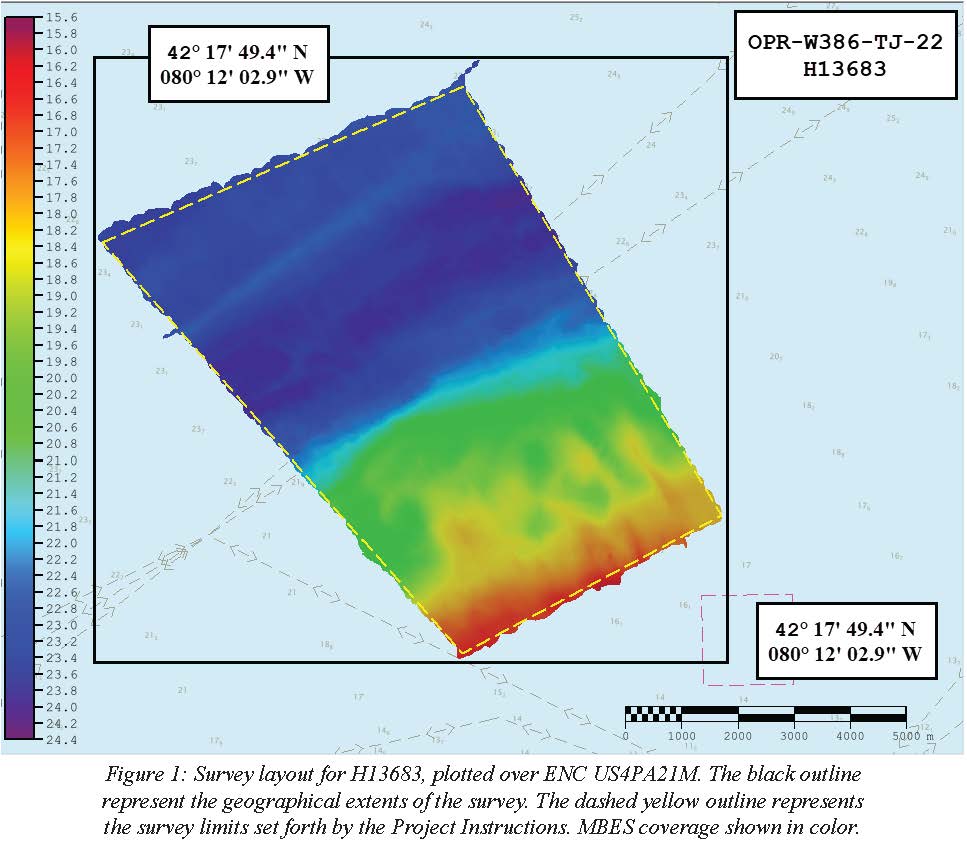
Federal
H13683: NOS Hydrographic Survey , 2022-08-14
National Oceanic and Atmospheric Administration, Department of Commerce —
The National Oceanic and Atmospheric Administration (NOAA) has the statutory mandate to collect hydrographic data in support of nautical chart compilation for safe... -
Federal
2020 Cartographic Boundary File (KML), Current State Legislative District-Lower Chamber for Pennsylvania, 1:500,000
U.S. Census Bureau, Department of Commerce —
The 2020 cartographic boundary KMLs are simplified representations of selected geographic areas from the U.S. Census Bureau's Master Address File / Topologically... -
Federal
Digital Geologic-GIS Map of Johnstown Flood National Memorial and portions of Allegheny Portage Railroad National Historic Site, Pennsylvania (NPS, GRD, GRI, JOFL, JOFL_ALPO digital map) adapted from a Pennsylvania Geological Survey Water Resource Report map by McElroy (1998)
Department of the Interior —
The Digital Geologic-GIS Map of Johnstown Flood National Memorial and portions of Allegheny Portage Railroad National Historic Site, Pennsylvania is composed of GIS... -
Federal
Digital Surficial Geologic-GIS Map of the part of the Lake Maskenozha Quadrangle, New Jersey and Pennsylvania (NPS, GRD, GRI, DEWA, LAMA_surficial digital map) adapted from a New Jersey Geological Survey Open-file Map by Witte (2014)
Department of the Interior —
The Digital Surficial Geologic-GIS Map of the part of the Lake Maskenozha Quadrangle, New Jersey and Pennsylvania is composed of GIS data layers and GIS tables, and... -
Federal
F00504: NOS Hydrographic Survey , Delaware Bay, Pennsylvania, 2004-12-07
National Oceanic and Atmospheric Administration, Department of Commerce —
The National Oceanic and Atmospheric Administration (NOAA) has the statutory mandate to collect hydrographic data in support of nautical chart compilation for safe... -
Federal
2022 Cartographic Boundary File (SHP), Current Place for Pennsylvania, 1:500,000
U.S. Census Bureau, Department of Commerce —
The 2022 cartographic boundary shapefiles are simplified representations of selected geographic areas from the U.S. Census Bureau's Master Address File /... -
Federal
Digital Bedrock Geologic-GIS Map of Allegheny Portage Railroad National Historic Site, Johnstown Flood National Memorial and Vicinity, Pennsylvania (NPS, GRD, GRI, ALPO, JOFL, ALPO_JOFL_bedrock digital map) adapted from a Pennsylvania Geological Survey published digital data by Berg, Edmunds, Geyer and others, plus compilers (2001)
Department of the Interior —
The Digital Bedrock Geologic-GIS Map of Allegheny Portage Railroad National Historic Site, Johnstown Flood National Memorial and Vicinity, Pennsylvania is composed of...

Official websites use .gov
A
.gov website belongs to an official government
organization in the United States.
Secure .gov websites use HTTPS
A
lock (
) or https:// means you’ve safely connected to
the .gov website. Share sensitive information only on official,
secure websites.
.jpg)