
-
Federal
Sea Level Trends: Sea Level Variations of the United States Derived from National Water Level Observation Network Stations NGDA 50 recent views
National Oceanic and Atmospheric Administration, Department of Commerce —
Water level records are a combination of the fluctuations of the ocean and the vertical land motion at the location of the station. Monthly mean sea level (MSL)... -
Federal
Tides and Currents Map: an interactive map of all CO-OPS stations NGDA 27 recent views
National Oceanic and Atmospheric Administration, Department of Commerce —
This interactive map has many features designed to provide a quick and easy way to find a Center for Operational Oceanographic Products and Services (CO-OPS) station.... -
Federal
National Hydrography Dataset Plus - NHDPlus 16 recent views
U.S. Environmental Protection Agency —
This high-level metadata data document will be supplemented with detailed regional metadata at a later date. The NHDPlusV2 is an integrated suite of application-ready... -
Federal
Coastal Change Analysis Program (C-CAP) High Resolution Land Cover and Change Data NGDA 13 recent views
National Oceanic and Atmospheric Administration, Department of Commerce —
The NOAA Coastal Change Analysis Program (C-CAP) produces national standardized high resolution land cover and change products for the coastal regions of the U.S. and... -
Federal
Willapa Bay, Washington Benthic Habitats 1995 Substrate
National Oceanic and Atmospheric Administration, Department of Commerce —
In June 1995, the Columbia River Estuary Study Taskforce (CREST) acquired 295 true color aerial photographs (1:12,000) of Willapa Bay, Washington, from the State of... -
Federal
Monterey, California Coastal Digital Elevation Model
National Oceanic and Atmospheric Administration, Department of Commerce —
NOAA's National Geophysical Data Center (NGDC) is building high-resolution digital elevation models (DEMs) for select U.S. coastal regions. These integrated... -
Federal
High Tide Flooding Products from NOAA CO-OPS
National Oceanic and Atmospheric Administration, Department of Commerce —
High tide flooding is the overflow or excess accumulation of water that covers typically dry coastal land and occurs during high tides. As relative sea levels rise,... -
Federal
NOAA/WDS Paleoclimatology - Global Lake-Level Variations from 18,000 to 0 Years Ago: A Paleoclimatic Analysis
National Oceanic and Atmospheric Administration, Department of Commerce —
This archived Paleoclimatology Study is available from the NOAA National Centers for Environmental Information (NCEI), under the World Data Service (WDS) for... -
Federal
Meteorological Data (including visibility)
National Oceanic and Atmospheric Administration, Department of Commerce —
The National Ocean Service (NOS) maintains a long-term database containing data from active and historic stations installed all over the United States and U.S.... -
Federal
NOAA/WDS Paleoclimatology - Appleton - Llao Rock - TSME - ITRDB OR099
National Oceanic and Atmospheric Administration, Department of Commerce —
This archived Paleoclimatology Study is available from the NOAA National Centers for Environmental Information (NCEI), under the World Data Service (WDS) for... -
Federal
NOAA/WDS Paleoclimatology - Wickman - Emigrant Springs - PIPO - ITRDB OR034
National Oceanic and Atmospheric Administration, Department of Commerce —
This archived Paleoclimatology Study is available from the NOAA National Centers for Environmental Information (NCEI), under the World Data Service (WDS) for... -
Federal
Columbia River, WA/OR (P260) Bathymetric Digital Elevation Model (30 meter resolution) Derived From Source Hydrographic Survey Soundings Collected by NOAA
National Oceanic and Atmospheric Administration, Department of Commerce —
Bathymetry for the Columbia River was derived from forty-five surveys containing 306,711 soundings. Nine older, overlapping, less accurate surveys were omitted before... -
Federal
Seagrass distribution off California
National Oceanic and Atmospheric Administration, Department of Commerce —
These data are a compilation of currently available seagrass GIS data sets for the west coast of the United States. These data have been compiled from seventeen... -
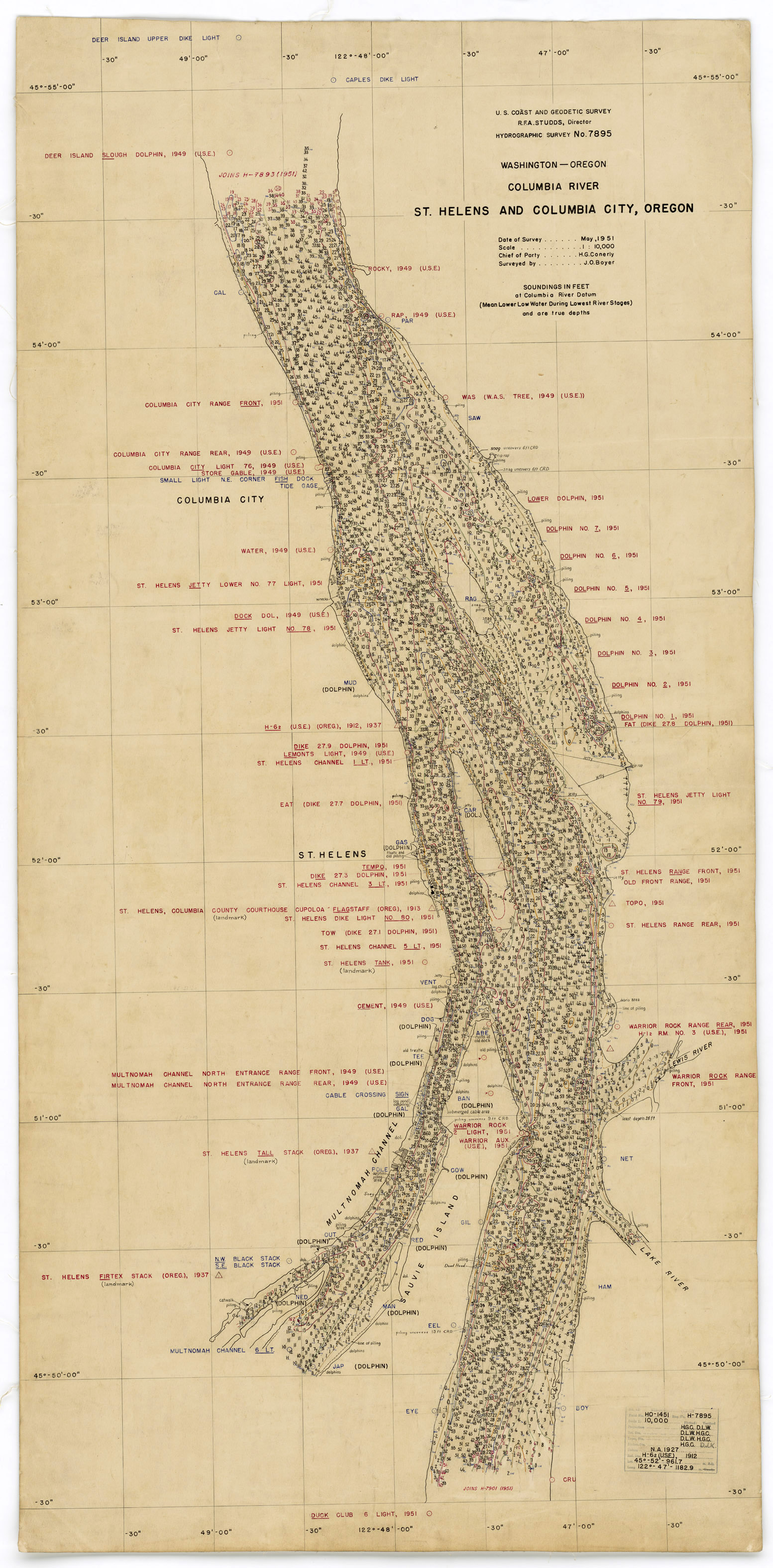
Federal
H07895: NOS Hydrographic Survey , 1951-12-31
National Oceanic and Atmospheric Administration, Department of Commerce —
The National Oceanic and Atmospheric Administration (NOAA) has the statutory mandate to collect hydrographic data in support of nautical chart compilation for safe... -
Federal
H07180: NOS Hydrographic Survey , 1947-12-31
National Oceanic and Atmospheric Administration, Department of Commerce —
The National Oceanic and Atmospheric Administration (NOAA) has the statutory mandate to collect hydrographic data in support of nautical chart compilation for safe... -
Federal
H00273: NOS Hydrographic Survey
National Oceanic and Atmospheric Administration, Department of Commerce —
The National Oceanic and Atmospheric Administration (NOAA) has the statutory mandate to collect hydrographic data in support of nautical chart compilation for safe... -
Federal
H07178: NOS Hydrographic Survey , 1947-12-31
National Oceanic and Atmospheric Administration, Department of Commerce —
The National Oceanic and Atmospheric Administration (NOAA) has the statutory mandate to collect hydrographic data in support of nautical chart compilation for safe... -
Federal
H02574: NOS Hydrographic Survey
National Oceanic and Atmospheric Administration, Department of Commerce —
The National Oceanic and Atmospheric Administration (NOAA) has the statutory mandate to collect hydrographic data in support of nautical chart compilation for safe... -
Federal
H06333: NOS Hydrographic Survey , 1938-12-31
National Oceanic and Atmospheric Administration, Department of Commerce —
The National Oceanic and Atmospheric Administration (NOAA) has the statutory mandate to collect hydrographic data in support of nautical chart compilation for safe... -
Federal
H01724: NOS Hydrographic Survey
National Oceanic and Atmospheric Administration, Department of Commerce —
The National Oceanic and Atmospheric Administration (NOAA) has the statutory mandate to collect hydrographic data in support of nautical chart compilation for safe...

Official websites use .gov
A
.gov website belongs to an official government
organization in the United States.
Secure .gov websites use HTTPS
A
lock (
) or https:// means you’ve safely connected to
the .gov website. Share sensitive information only on official,
secure websites.