
-
Federal
Unpublished Digital Geologic Map of Glen Canyon National Recreation Area and Vicinity, Utah, and Arizona (NPS, GRD, GRI, GLCA, GLCA digital map) adapted from Utah Geological Survey digital data and map by Willis and Ehler (2011), and Open-File Report map by Doelling and Willis (1999)
Department of the Interior —
The Unpublished Digital Geologic Map of Glen Canyon National Recreation Area and Vicinity, Utah, Arizona is composed of GIS data layers complete with ArcMap 9.3 layer... -
Federal
2022 Cartographic Boundary File (KML), Current State Legislative District-Upper Chamber for Arizona, 1:500,000
U.S. Census Bureau, Department of Commerce —
The 2022 cartographic boundary KMLs are simplified representations of selected geographic areas from the U.S. Census Bureau's Master Address File / Topologically... -
Federal
2020 Cartographic Boundary File (KML), Current Place for Arizona, 1:500,000
U.S. Census Bureau, Department of Commerce —
The 2020 cartographic boundary KMLs are simplified representations of selected geographic areas from the U.S. Census Bureau's Master Address File / Topologically... -
Federal
BLM Natl WesternUS GRSG Disturbance Compilation 2021
Department of the Interior —
PDF version of the final report for the 2015 through 2021 Estimates of Disturbance on Greater Sage-Grouse Priority and Important Habitat Management Areas within the... -
Federal
2022 Cartographic Boundary File (KML), Current Place for Arizona, 1:500,000
U.S. Census Bureau, Department of Commerce —
The 2022 cartographic boundary KMLs are simplified representations of selected geographic areas from the U.S. Census Bureau's Master Address File / Topologically... -
Federal
2022 Cartographic Boundary File (SHP), Current Unified School District for Arizona, 1:500,000
U.S. Census Bureau, Department of Commerce —
The 2022 cartographic boundary shapefiles are simplified representations of selected geographic areas from the U.S. Census Bureau's Master Address File /... -
Federal
2022 Cartographic Boundary File (KML), Current Unified School District for Arizona, 1:500,000
U.S. Census Bureau, Department of Commerce —
The 2022 cartographic boundary KMLs are simplified representations of selected geographic areas from the U.S. Census Bureau's Master Address File / Topologically... -
Federal
2020 Cartographic Boundary File (SHP), 2020 Census Voting District (VTD) for Arizona, 1:500,000
U.S. Census Bureau, Department of Commerce —
The 2020 cartographic boundary shapefiles are simplified representations of selected geographic areas from the U.S. Census Bureau's Master Address File /... -
Federal
Digital Geologic-GIS Map of a portion of Petrified Forest National Park, Arizona (NPS, GRD, GRI, PEFO, PEFO digital map) adapted from a Arizona Geological Survey Contributed Map Series map by Martz, Parker, Thompson and Raucci (2012)
Department of the Interior —
The Digital Geologic-GIS Map of a portion of Petrified Forest National Park, Arizona is composed of GIS data layers and GIS tables, and is available in the following... -
Federal
NOAA/WDS Paleoclimatology - Baisan fire data from Hitchcock - IMPD USHIT001
National Oceanic and Atmospheric Administration, Department of Commerce —
This archived Paleoclimatology Study is available from the NOAA National Centers for Environmental Information (NCEI), under the World Data Service (WDS) for... -
Federal
2020 Cartographic Boundary File (KML), Current State Legislative District-Lower Chamber for Arizona, 1:500,000
U.S. Census Bureau, Department of Commerce —
The 2020 cartographic boundary KMLs are simplified representations of selected geographic areas from the U.S. Census Bureau's Master Address File / Topologically... -
Federal
2020 Cartographic Boundary File (KML), Current Secondary School District for Arizona, 1:500,000
U.S. Census Bureau, Department of Commerce —
The 2020 cartographic boundary KMLs are simplified representations of selected geographic areas from the U.S. Census Bureau's Master Address File / Topologically... -
Federal
2022 Cartographic Boundary File (SHP), Current State Legislative District-Upper Chamber for Arizona, 1:500,000
U.S. Census Bureau, Department of Commerce —
The 2022 cartographic boundary shapefiles are simplified representations of selected geographic areas from the U.S. Census Bureau's Master Address File /... -
Federal
Digital Geologic-GIS Map of the Buell Park Quadrangle, Arizona and New Mexico (NPS, GRD, GRI, CACH, BUPA digital map) adapted from a U.S. Geological Survey Geologic Quadrangle Map by Thaden (1990)
Department of the Interior —
The Digital Geologic-GIS Map of the Buell Park Quadrangle, Arizona and New Mexico is composed of GIS data layers and GIS tables, and is available in the following... -
Federal
NOAA/WDS Paleoclimatology - Gungle fire data from Josephine Saddle - IMPD USJSS001
National Oceanic and Atmospheric Administration, Department of Commerce —
This archived Paleoclimatology Study is available from the NOAA National Centers for Environmental Information (NCEI), under the World Data Service (WDS) for... -
Federal
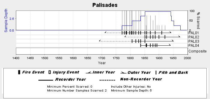
NOAA/WDS Paleoclimatology - Swetnam fire data from Palisades - IMPD USPAL001
National Oceanic and Atmospheric Administration, Department of Commerce —
This archived Paleoclimatology Study is available from the NOAA National Centers for Environmental Information (NCEI), under the World Data Service (WDS) for... -
Federal
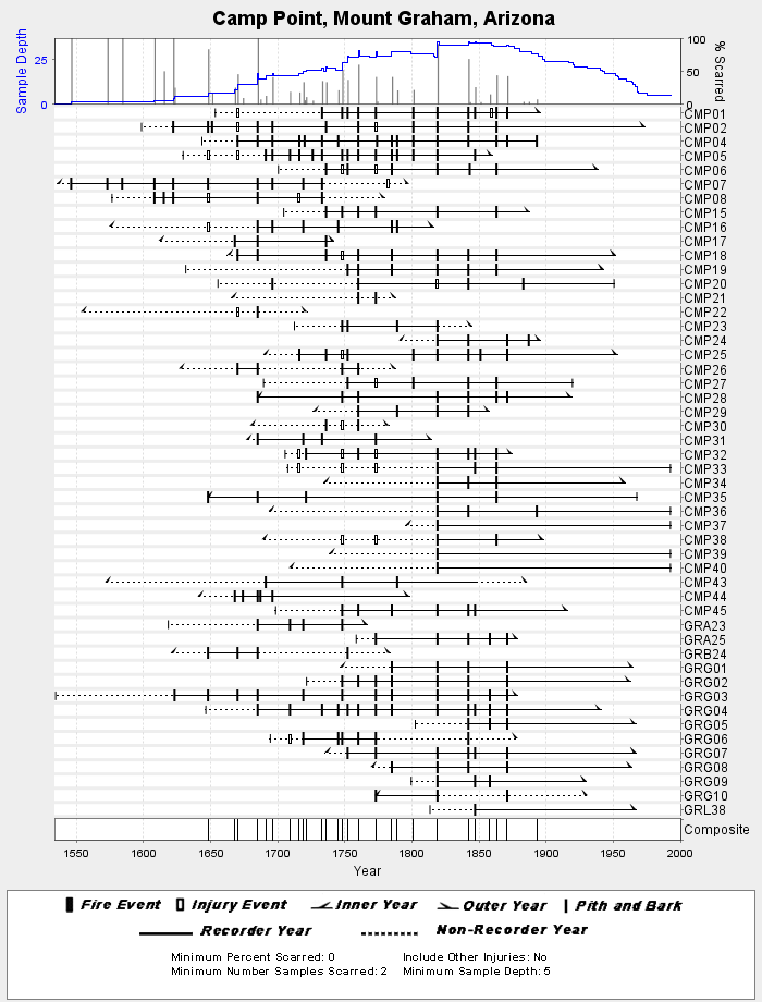
NOAA/WDS Paleoclimatology - Grissino-Mayer fire data from Camp Point, Mount Graham - IMPD USCMP001
National Oceanic and Atmospheric Administration, Department of Commerce —
This archived Paleoclimatology Study is available from the NOAA National Centers for Environmental Information (NCEI), under the World Data Service (WDS) for... -
Federal
NOAA/WDS Paleoclimatology - Heinlein fire data from San Francisco Peaks (West) - IMPD USSPW001
National Oceanic and Atmospheric Administration, Department of Commerce —
This archived Paleoclimatology Study is available from the NOAA National Centers for Environmental Information (NCEI), under the World Data Service (WDS) for... -
Federal
H06733: NOS Hydrographic Survey , 1942-05-09
National Oceanic and Atmospheric Administration, Department of Commerce —
The National Oceanic and Atmospheric Administration (NOAA) has the statutory mandate to collect hydrographic data in support of nautical chart compilation for safe... -
Federal
2020 Cartographic Boundary File (KML), 2020 Public Use Microdata Areas for Arizona, 1:500,000
U.S. Census Bureau, Department of Commerce —
The 2020 cartographic boundary KMLs are simplified representations of selected geographic areas from the U.S. Census Bureau's Master Address File / Topologically...

Official websites use .gov
A
.gov website belongs to an official government
organization in the United States.
Secure .gov websites use HTTPS
A
lock (
) or https:// means you’ve safely connected to
the .gov website. Share sensitive information only on official,
secure websites.