
-
Federal
H11898: NOS Hydrographic Survey , East of Key Biscayne, Florida, 2009-07-06
National Oceanic and Atmospheric Administration, Department of Commerce —
The National Oceanic and Atmospheric Administration (NOAA) has the statutory mandate to collect hydrographic data in support of nautical chart compilation for safe... -
Federal
H13331: NOS Hydrographic Survey , 2019-10-17
National Oceanic and Atmospheric Administration, Department of Commerce —
The National Oceanic and Atmospheric Administration (NOAA) has the statutory mandate to collect hydrographic data in support of nautical chart compilation for safe... -
Federal
H13290: NOS Hydrographic Survey , 2020-10-16
National Oceanic and Atmospheric Administration, Department of Commerce —
The National Oceanic and Atmospheric Administration (NOAA) has the statutory mandate to collect hydrographic data in support of nautical chart compilation for safe... -
Federal
H11532: NOS Hydrographic Survey , Approaches to Cape Canaveral, Florida, 2006-06-12
National Oceanic and Atmospheric Administration, Department of Commerce —
The National Oceanic and Atmospheric Administration (NOAA) has the statutory mandate to collect hydrographic data in support of nautical chart compilation for safe... -
Federal
H13358: NOS Hydrographic Survey , 2020-09-26
National Oceanic and Atmospheric Administration, Department of Commerce —
The National Oceanic and Atmospheric Administration (NOAA) has the statutory mandate to collect hydrographic data in support of nautical chart compilation for safe... -
Federal
H13160: NOS Hydrographic Survey , 2019-01-12
National Oceanic and Atmospheric Administration, Department of Commerce —
The National Oceanic and Atmospheric Administration (NOAA) has the statutory mandate to collect hydrographic data in support of nautical chart compilation for safe... -
Federal
H11869: NOS Hydrographic Survey , Approaches to Miami, Florida, 2008-08-26
National Oceanic and Atmospheric Administration, Department of Commerce —
The National Oceanic and Atmospheric Administration (NOAA) has the statutory mandate to collect hydrographic data in support of nautical chart compilation for safe... -
Federal
H11533: NOS Hydrographic Survey , Approaches to Cape Canaveral, Florida, 2007-05-28
National Oceanic and Atmospheric Administration, Department of Commerce —
The National Oceanic and Atmospheric Administration (NOAA) has the statutory mandate to collect hydrographic data in support of nautical chart compilation for safe... -
Federal
H13176: NOS Hydrographic Survey , 2019-06-21
National Oceanic and Atmospheric Administration, Department of Commerce —
The National Oceanic and Atmospheric Administration (NOAA) has the statutory mandate to collect hydrographic data in support of nautical chart compilation for safe... -
Federal
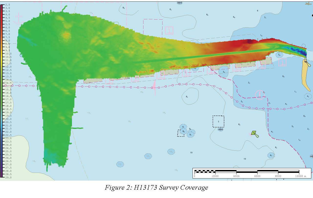
H13173: NOS Hydrographic Survey , 2019-07-21
National Oceanic and Atmospheric Administration, Department of Commerce —
The National Oceanic and Atmospheric Administration (NOAA) has the statutory mandate to collect hydrographic data in support of nautical chart compilation for safe... -
Federal
H13174: NOS Hydrographic Survey , 2019-07-03
National Oceanic and Atmospheric Administration, Department of Commerce —
The National Oceanic and Atmospheric Administration (NOAA) has the statutory mandate to collect hydrographic data in support of nautical chart compilation for safe... -
Federal
2021 Oregon II 340 Hypoxia Watch Bottom Dissolved Oxygen Contours
National Oceanic and Atmospheric Administration, Department of Commerce —
The NOAA Hypoxia Watch project provides near-real-time, web-based maps of dissolved oxygen near the sea floor over the Texas-Louisiana continental shelf during a... -
Federal
F00640: NOS Hydrographic Survey , Port of Miami, FL, 2014-01-31
National Oceanic and Atmospheric Administration, Department of Commerce —
The National Oceanic and Atmospheric Administration (NOAA) has the statutory mandate to collect hydrographic data in support of nautical chart compilation for safe... -
Federal
ASV_SEISMICSHOT500 - Shot Points at 500 Shot Intervals for Seismic Data Collected with Autonomous Surface Vehicle (ASV) IRIS in Apalachicola Bay and St. George Sound, FL.
National Oceanic and Atmospheric Administration, Department of Commerce —
These data were collected under a cooperative mapping program between the U.S. Geological Survey (USGS), the National Oceanic and Atmospheric Administration Office... -
Federal
NOAA TIFF Image - 10m Multibeam Bathymetry, South Atlantic Bight - Deep Coral Priority Areas - NOAA Ship Nancy Foster - (2009), UTM 17N NAD83
National Oceanic and Atmospheric Administration, Department of Commerce —
This dataset contains a unified GeoTiff with 10x10 meter cell size representing the bathymetry of several deep coral priority areas off the South Atlantic Bight,... -
Federal
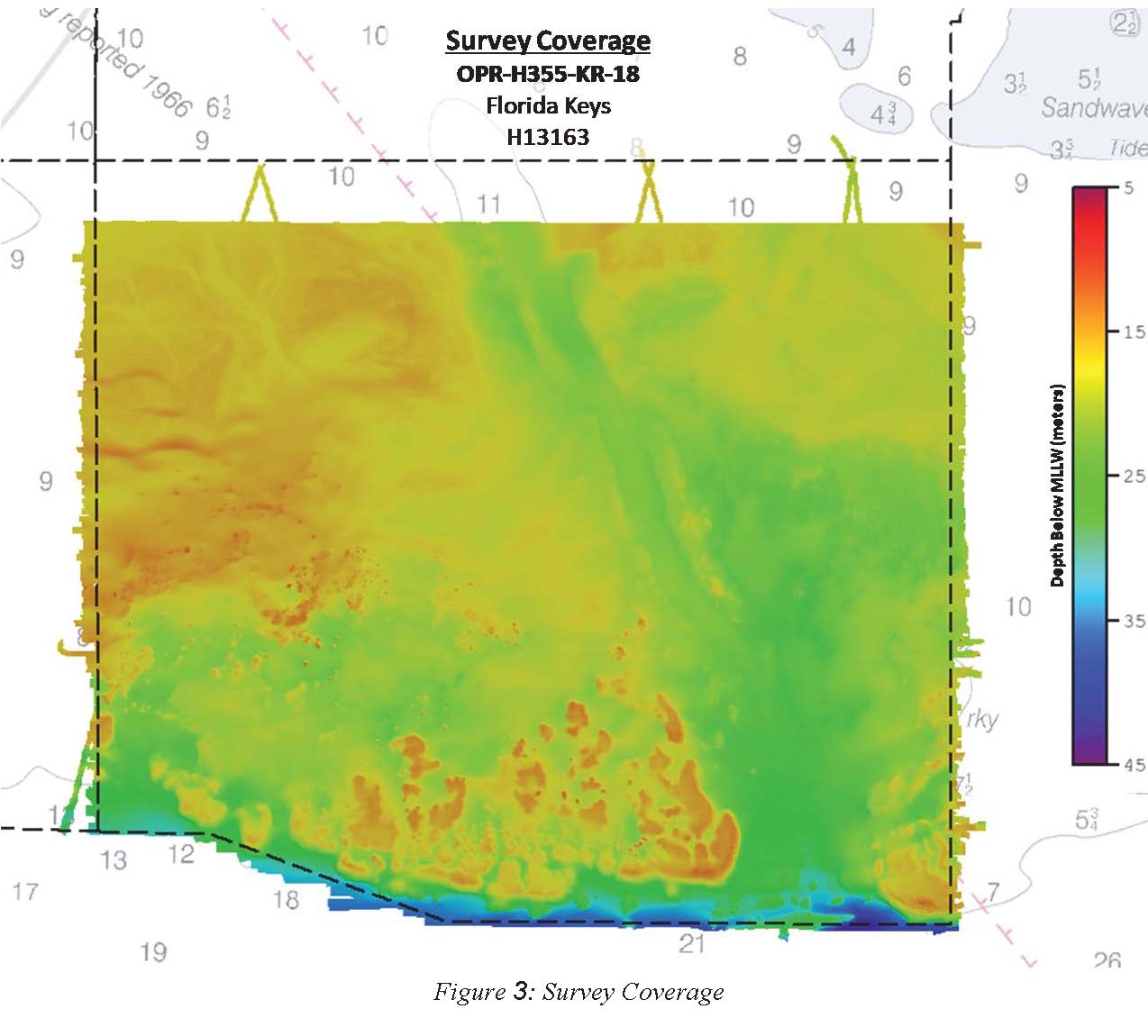
H13163: NOS Hydrographic Survey , 2019-02-03
National Oceanic and Atmospheric Administration, Department of Commerce —
The National Oceanic and Atmospheric Administration (NOAA) has the statutory mandate to collect hydrographic data in support of nautical chart compilation for safe...

Official websites use .gov
A
.gov website belongs to an official government
organization in the United States.
Secure .gov websites use HTTPS
A
lock (
) or https:// means you’ve safely connected to
the .gov website. Share sensitive information only on official,
secure websites.
.jpg)
.jpg)