
-
Federal
CRED SVP Drifting Buoy Argos_ID 29101 Data, Kure Atoll in the Northwestern Hawaiian Islands, 200308-200509 (NODC Accession 0049436)
National Oceanic and Atmospheric Administration, Department of Commerce —
CRED SVP drifter Argos_ID 29101 was deployed in the region of NW Hawaiian Islands to assess ocean currents and sea surface temperature. SVP drifter data files contain... -
Federal
CRED SVP Drifting Buoy Argos_ID 30350 Data near Laysan Island in the NW Hawaiian Islands, 200209-200412 (NODC Accession 0049436)
National Oceanic and Atmospheric Administration, Department of Commerce —
CRED SVP drifter Argos_ID 30350 was deployed in the region of NW Hawaiian Islands to assess ocean currents and sea surface temperature. SVP drifter data files contain... -
Federal
CRED Cumulative Map of Percent Scleractinian Coral Cover at Pearl and Hermes Atoll, 2002-2004
National Oceanic and Atmospheric Administration, Department of Commerce —
This map displays optical validation observation locations and percent coverage of scleractinian coral overlaid on bathymetry. -
Federal
CRED APEX Drifting Buoy Argos_ID 24963 Data in the NW Hawaiian Islands, 200109-200506 (NODC Accession 0049436)
National Oceanic and Atmospheric Administration, Department of Commerce —
CRED APEX drifter Argos_ID 24963 was deployed in the region of NW Hawaiian Islands to assess ocean currents and sea surface temperature. APEX drifter data files... -
Federal
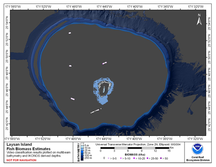
CRED Fish Biomass Estimates map at Laysan Island
National Oceanic and Atmospheric Administration, Department of Commerce —
This map displays fish biomass observation locations overlaid on bathymetry -
Federal
CRED SVP Drifting Buoy Argos_ID 30311 Data between Nihoa and Niihau in the NW Hawaiian Islands, 200210-200402 (NODC Accession 0049436)
National Oceanic and Atmospheric Administration, Department of Commerce —
CRED SVP drifter Argos_ID 30311 was deployed in the region of NW Hawaiian Islands to assess ocean currents and sea surface temperature. SVP drifter data files contain... -
Federal
CRED Cumulative Map of Percent Scleractinian Coral Cover at Niihau, 2005
National Oceanic and Atmospheric Administration, Department of Commerce —
This map displays optical validation observation locations and percent coverage of scleractinian coral overlaid on bathymetry. -
Federal
CRED SVP Drifting Buoy Argos_ID 29106 Data, Laysan Island in the Northwestern Hawaiian Islands, 200307-200411 (NODC Accession 0049436)
National Oceanic and Atmospheric Administration, Department of Commerce —
CRED SVP drifter Argos_ID 29106 was deployed in the region of NW Hawaiian Islands to assess ocean currents and sea surface temperature. SVP drifter data files contain... -
Federal
CRED APEX Drifting Buoy Argos_ID 25332 Data in the NW Hawaiian Islands, 200110-200503 (NODC Accession 0049436)
National Oceanic and Atmospheric Administration, Department of Commerce —
CRED APEX drifter Argos_ID 25332 was deployed in the region of NW Hawaiian Islands to assess ocean currents and sea surface temperature. APEX drifter data files... -
Federal
CRED APEX Drifting Buoy Argos_ID 25333 Data in the NW Hawaiian Islands, 200110-200204 (NODC Accession 0049436)
National Oceanic and Atmospheric Administration, Department of Commerce —
CRED APEX drifter Argos_ID 25333 was deployed in the region of NW Hawaiian Islands to assess ocean currents and sea surface temperature. APEX drifter data files... -
Federal
CRED SVP Drifting Buoy Argos_ID 30291 Data in the NW Hawaiian Islands, 20020920-20050105 (NODC Accession 0049436)
National Oceanic and Atmospheric Administration, Department of Commerce —
CRED SVP drifter Argos_ID 30291 was deployed in the region of NW Hawaiian Islands to assess ocean currents and sea surface temperature. SVP drifter data files contain... -
Federal
CRED SVP Drifting Buoy Argos_ID 29098 Data, Necker Island in the Northwestern Hawaiian Islands, 200307-200410 (NODC Accession 0049436)
National Oceanic and Atmospheric Administration, Department of Commerce —
CRED SVP drifter Argos_ID 29098 was deployed in the region of NW Hawaiian Islands to assess ocean currents and sea surface temperature. SVP drifter data files contain... -
Federal
CRED SVP Drifting Buoy Argos_ID 30225 Data in the Northwestern Hawaiian Islands, 200209-200401 (NODC Accession 0049436)
National Oceanic and Atmospheric Administration, Department of Commerce —
CRED SVP drifter Argos_ID 30225 was deployed in the region of NW Hawaiian Islands to assess ocean currents and sea surface temperature. SVP drifter data files contain... -
Federal
CRED Cumulative Map of Percent Scleractinian Coral Cover at Kure Atoll, 2002-2004
National Oceanic and Atmospheric Administration, Department of Commerce —
This map displays optical validation observation locations and percent coverage of scleractinian coral overlaid on bathymetry. -
Federal
CRED SVP Drifting Buoy Argos_ID 24953 Data at Laysan/Pioneer Bank in the NW Hawaiian Islands, 200110-200504 (NODC Accession 0049436)
National Oceanic and Atmospheric Administration, Department of Commerce —
CRED SVP drifter Argos_ID 24953 was deployed in the region of NW Hawaiian Islands to assess ocean currents and sea surface temperature. SVP drifter data files contain... -
Federal
Predicted Habitat Suitability for Montipora in the Au'au Channel Region
National Oceanic and Atmospheric Administration, Department of Commerce —
This raster denotes predicted habitat suitability for Montipora in the Auau Channel region. Maximum Entropy (MaxEnt) modeling software was used to create this... -
Federal
CRED Cumulative Map of Percent Scleractinian Coral Cover at Kauai, 2005
National Oceanic and Atmospheric Administration, Department of Commerce —
This map displays optical validation observation locations and percent coverage of scleractinian coral overlaid on bathymetry. -
Federal
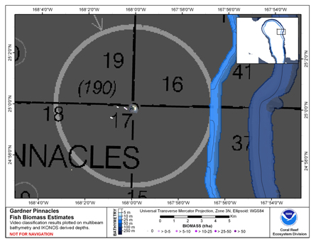
CRED Cumulative Fish Biomass Estimates Map at Gardner Pinnacles
National Oceanic and Atmospheric Administration, Department of Commerce —
This map displays fish biomass observation locations overlaid on bathymetry. -
Federal
CRED APEX Drifting Buoy Argos_ID 25321 Data in the Northwestern Hawaiian Islands, 200110-200404 (NODC Accession 0049436)
National Oceanic and Atmospheric Administration, Department of Commerce —
CRED APEX drifter Argos_ID 25321 was deployed in the region of NW Hawaiian Islands to assess ocean currents and sea surface temperature. APEX drifter data files... -
Federal
CRED SVP Drifting Buoy Argos_ID 30111 Data, French Frigate Shoals in the Northwestern Hawaiian Islands, 200210-200309 (NODC Accession 0049436)
National Oceanic and Atmospheric Administration, Department of Commerce —
CRED SVP drifter Argos_ID 30111 was deployed in the region of NW Hawaiian Islands to assess ocean currents and sea surface temperature. SVP drifter data files contain...

Official websites use .gov
A
.gov website belongs to an official government
organization in the United States.
Secure .gov websites use HTTPS
A
lock (
) or https:// means you’ve safely connected to
the .gov website. Share sensitive information only on official,
secure websites.