
-
Federal
Shoreline Mapping Program of Bass Islands, Lake Erie, OH, OH1603-CM-N NGDA
National Oceanic and Atmospheric Administration, Department of Commerce —
These data provide an accurate high-resolution shoreline compiled from imagery of Bass Islands, Lake Erie, OH . This vector shoreline data is based on an office... -
Federal
H13614: NOS Hydrographic Survey , 2022-10-03
National Oceanic and Atmospheric Administration, Department of Commerce —
The National Oceanic and Atmospheric Administration (NOAA) has the statutory mandate to collect hydrographic data in support of nautical chart compilation for safe... -
Federal
Shoreline Data Rescue Project of Vermilion to Fairport Harbor, CM-7510 NGDA
National Oceanic and Atmospheric Administration, Department of Commerce —
These data were automated to provide an accurate high-resolution historical shoreline of Vermilion to Fairport Harbor suitable as a geographic information system... -
Federal
Shoreline Mapping Program of PORT OF CONNEAUT, OH, OH1502-CS-N NGDA
National Oceanic and Atmospheric Administration, Department of Commerce —
These data provide an accurate high-resolution shoreline compiled from imagery of PORT OF CONNEAUT, OH . This vector shoreline data is based on an office... -
Federal
Meteorological Data (including visibility)
National Oceanic and Atmospheric Administration, Department of Commerce —
The National Ocean Service (NOS) maintains a long-term database containing data from active and historic stations installed all over the United States and U.S.... -
Federal
Shoreline Mapping Program of Port of Ashtabula, OH, OH2002-CS-T NGDA
National Oceanic and Atmospheric Administration, Department of Commerce —
These data provide an accurate high-resolution shoreline compiled from imagery of Port of Ashtabula, OH . This vector shoreline data is based on an office... -
Federal
Shoreline Mapping Program of Port of Toledo, OH, OH1606-CS-N NGDA
National Oceanic and Atmospheric Administration, Department of Commerce —
These data provide an accurate high-resolution shoreline compiled from imagery of Port of Toledo, OH . This vector shoreline data is based on an office interpretation... -
Federal
H13612: NOS Hydrographic Survey , 2022-06-14
National Oceanic and Atmospheric Administration, Department of Commerce —
The National Oceanic and Atmospheric Administration (NOAA) has the statutory mandate to collect hydrographic data in support of nautical chart compilation for safe... -
Federal
Shoreline Data Rescue Project of Lake Erie, West End, Ohio - Michigan, CM-7603 NGDA
National Oceanic and Atmospheric Administration, Department of Commerce —
These data were automated to provide an accurate high-resolution historical shoreline of Lake Erie, West End, Ohio - Michigan suitable as a geographic information... -
Federal
Shoreline Mapping Program of Port of Huron, OH, OH1601C-CS-N NGDA
National Oceanic and Atmospheric Administration, Department of Commerce —
These data provide an accurate high-resolution shoreline compiled from imagery of Port of Huron, OH . This vector shoreline data is based on an office interpretation... -
Federal
Shoreline Mapping Program of Port of Cleveland, OH, OH1604-CS-N NGDA
National Oceanic and Atmospheric Administration, Department of Commerce —
These data provide an accurate high-resolution shoreline compiled from imagery of Port of Cleveland, OH . This vector shoreline data is based on an office... -
Federal
Coastal Mapping Program of Fairport Harbor, OH, OH2005-CS-N NGDA
National Oceanic and Atmospheric Administration, Department of Commerce —
These data provide an accurate high-resolution shoreline compiled from imagery of Fairport Harbor, OH . This vector shoreline data is based on an office... -
Federal
Shoreline Mapping Program of Port of Kelleys Island, OH, OH1601B-CS-N NGDA
National Oceanic and Atmospheric Administration, Department of Commerce —
These data provide an accurate high-resolution shoreline compiled from imagery of Port of Kelleys Island, OH . This vector shoreline data is based on an office... -
Federal
Shoreline Mapping Program of LAKE ERIE, HURON TO CONNEAUT, OH, OH0906D NGDA
National Oceanic and Atmospheric Administration, Department of Commerce —
These data provide an accurate high-resolution shoreline compiled from imagery of LAKE ERIE, HURON TO CONNEAUT, OH . This vector shoreline data is based on an office... -
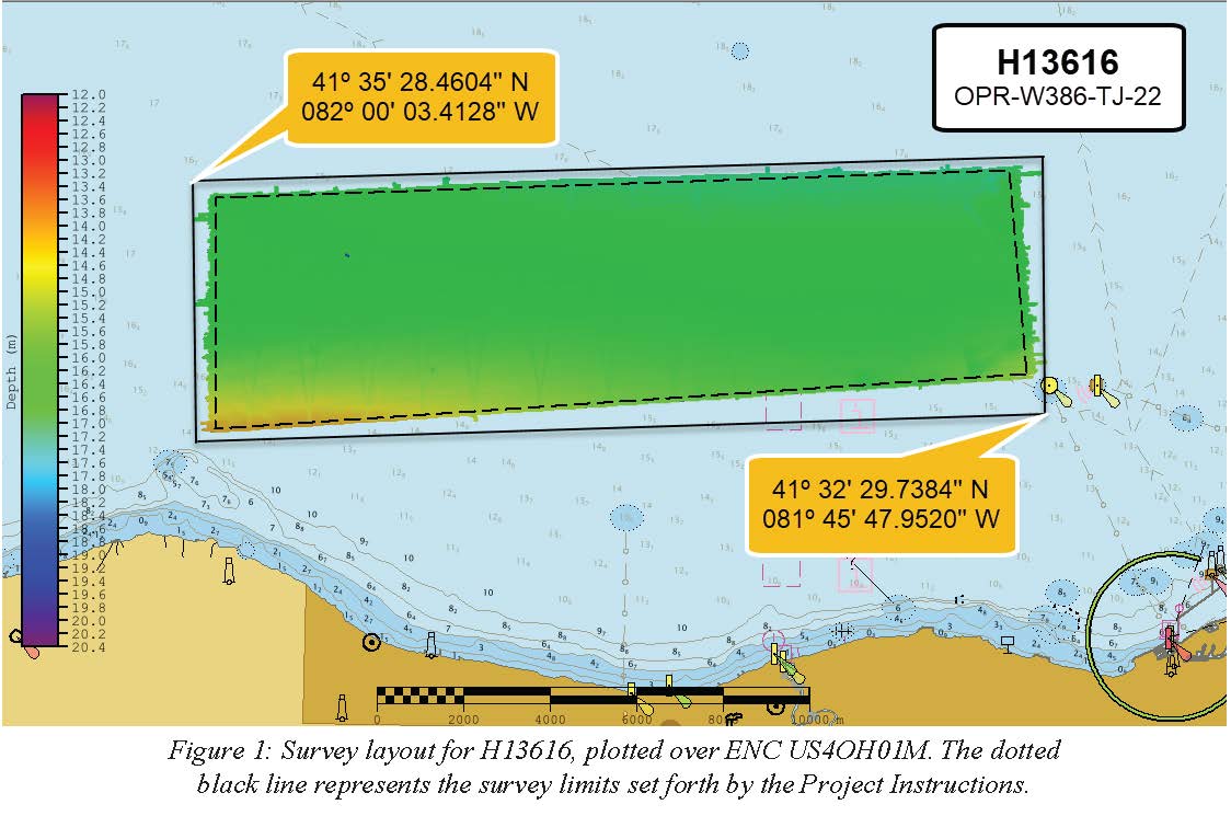
Federal
H13616: NOS Hydrographic Survey , 2022-06-21
National Oceanic and Atmospheric Administration, Department of Commerce —
The National Oceanic and Atmospheric Administration (NOAA) has the statutory mandate to collect hydrographic data in support of nautical chart compilation for safe... -
Federal
H13607: NOS Hydrographic Survey , 2022-08-18
National Oceanic and Atmospheric Administration, Department of Commerce —
The National Oceanic and Atmospheric Administration (NOAA) has the statutory mandate to collect hydrographic data in support of nautical chart compilation for safe... -
Federal
H09656: NOS Hydrographic Survey , Conneaut Harbor and Approaches, Ohio, 1976-10-05
National Oceanic and Atmospheric Administration, Department of Commerce —
The National Oceanic and Atmospheric Administration (NOAA) has the statutory mandate to collect hydrographic data in support of nautical chart compilation for safe... -
Federal
H09654: NOS Hydrographic Survey , Conneaut Harbor and Approaches, Ohio, 1976-08-05
National Oceanic and Atmospheric Administration, Department of Commerce —
The National Oceanic and Atmospheric Administration (NOAA) has the statutory mandate to collect hydrographic data in support of nautical chart compilation for safe... -
Federal
H09536: NOS Hydrographic Survey , South Shore of Lake Erie, Ohio, 1974-12-31
National Oceanic and Atmospheric Administration, Department of Commerce —
The National Oceanic and Atmospheric Administration (NOAA) has the statutory mandate to collect hydrographic data in support of nautical chart compilation for safe... -
Federal
H13687: NOS Hydrographic Survey , 2022-10-03
National Oceanic and Atmospheric Administration, Department of Commerce —
The National Oceanic and Atmospheric Administration (NOAA) has the statutory mandate to collect hydrographic data in support of nautical chart compilation for safe...

Official websites use .gov
A
.gov website belongs to an official government
organization in the United States.
Secure .gov websites use HTTPS
A
lock (
) or https:// means you’ve safely connected to
the .gov website. Share sensitive information only on official,
secure websites.