
-
Federal
CYGNSS Level 1 Science Data Record Version 2.1
National Aeronautics and Space Administration —
This Level 1 (L1) dataset contains the Version 2.1 geo-located Delay Doppler Maps (DDMs) calibrated into Power Received (Watts) and Bistatic Radar Cross Section... -
Federal
SASSIE Arctic Field Campaign Shipboard S-Band Radar Level 3 Data Fall 2022
National Aeronautics and Space Administration —
This dataset contains images from the S-BAND marine navigation radar collected during the 2022 Salinity and Stratification at the Sea Ice Edge (SASSIE) campaign.... -
Federal
CYGNSS Level 1 Raw Intermediate Frequency Data Record
National Aeronautics and Space Administration —
This Level 1 (L1) dataset contains the Raw Intermediate Frequency (IF) sensor data from the Delay Doppler Mapping Instrument aboard the CYGNSS satellite... -
Federal
NSCAT Gridded Level 3 Enhanced Resolution Sigma-0 from BYU
National Aeronautics and Space Administration —
This NASA Scatterometer (NSCAT) satellite Sigma-0 dataset is generated by the Scatterometer Climate Record Pathfinder (SCP) project at Brigham Young University (BYU)... -
Federal
NOAA CYGNSS Level 2 Science Wind Speed 25-km Product Version 1.1
National Aeronautics and Space Administration —
This dataset contains the Version 1.1 NOAA CYGNSS Level 2 Science Wind Speed Product Version 1.1 which provides the time-tagged and geolocated average wind speed... -
Federal
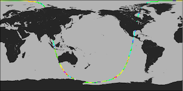
SWOT Level 1B Low-Rate Interferogram Data Product, Version 2.0
National Aeronautics and Space Administration —
Interferograms for each of the 9 Doppler beams formed and spatially averaged (low rate) by the On Board Processor, corrected on the ground for phase biases (inherent... -
Federal
CYGNSS Level 1 Science Data Record Version 3.2
National Aeronautics and Space Administration —
This CYGNSS Level 1 (L1) science data record dataset contains the version 3.2 geo-located Delay Doppler Maps (DDMs) calibrated into Power Received (Watts) and... -
Federal
SWOT Level 2 Radiometer Brightness Temperatures and Troposphere Interim Data Product Version 1.0
National Aeronautics and Space Administration —
The SWOT Level 2 Radiometer Brightness Temperatures and Troposphere Interim Geophysical Data Record (IGDR) Version 1.0 dataset produced by the Surface Water and Ocean... -
Federal
SWOT Level 2 Radiometer Brightness Temperatures and Troposphere Operational Data Product, Version 2.0
National Aeronautics and Space Administration —
The SWOT Level 2 Radiometer Brightness Temperatures and Troposphere Operational Geophysical Data Record (OGDR) Version 1.0 dataset produced by the Surface Water and... -
Federal
RapidScat Level 1B Time-Ordered Geo-Located Sigma-0 Version 2.0
National Aeronautics and Space Administration —
This dataset contains the ISS-RapidScat Version 2.0 Level 1B geo-located Sigma-0 measurements and antenna pulse "egg" and "slice" geometries as derived from ephemeris... -
Federal
SWOT Level 2 Radiometer Brightness Temperatures and Troposphere Operational Data Product Version 1.0
National Aeronautics and Space Administration —
The SWOT Level 2 Radiometer Brightness Temperatures and Troposphere Operational Geophysical Data Record (OGDR) Version 1.0 dataset produced by the Surface Water and... -
Federal
CYGNSS Level 1 Full Delay Doppler Map Data Record Version 3.0
National Aeronautics and Space Administration —
This Level 1 (L1) dataset contains the Version 3.0 (v3.0) Full Delay Doppler Map (DDM) sensor data from the Delay Doppler Mapping Instrument aboard the CYGNSS... -
Federal
S-MODE DopplerScatt Level 2 Ocean Winds and Currents Version 1
National Aeronautics and Space Administration —
This dataset contains concurrent airborne DopplerScatt radar retrievals of surface vector winds and ocean currents from the Sub-Mesoscale Ocean Dynamics Experiment... -
Federal
QuikSCAT Level 1C Averaged Sigma-0 and Winds from Non-spinning Antenna Version 2.0
National Aeronautics and Space Administration —
This dataset is Version 2 of the geo-located and averaged Level 1B Sigma-0 measurements and wind retrievals from the SeaWinds on QuikSCAT platform, initiated in the... -
Federal
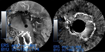
ERS-2 Gridded Level 3 Enhanced Resolution Sigma-0 from BYU
National Aeronautics and Space Administration —
This European Remote Sensing (ERS) Sigma-0 dataset is generated by the Scatterometer Climate Record Pathfinder (SCP) project at Brigham Young University (BYU) and is... -
Federal
SEASAT SCATTEROMETER BINNED 50KM SIGMA-0 DATA (Wentz)
National Aeronautics and Space Administration —
Contains Seasat-A Scatterometer (SASS) Sigma-0 measurements for the entire Seasat mission, from July 1978 until October 1978, produced by Frank Wentz at Remote... -
Federal
SASSIE Arctic Field Campaign Shipboard S-Band Radar Level 4 Data Fall 2022
National Aeronautics and Space Administration —
This dataset contains images from the S-BAND marine navigation radar collected during the 2022 Salinity and Stratification at the Sea Ice Edge (SASSIE) campaign.... -
Federal
SWOT Level 2 Radiometer Brightness Temperatures and Troposphere Interim Data Product, Version 2.0
National Aeronautics and Space Administration —
The SWOT Level 2 Radiometer Brightness Temperatures and Troposphere Interim Geophysical Data Record (IGDR) Version 1.0 dataset produced by the Surface Water and Ocean... -
Federal
CYGNSS Level 2 Science Data Record Version 2.1
National Aeronautics and Space Administration —
This dataset contains the Version 2.1 CYGNSS Level 2 Science Data Record which provides the time-tagged and geolocated average wind speed (m/s) and mean square slope... -
Federal
ERS-1 Gridded Level 3 Enhanced Resolution Sigma-0 from BYU
National Aeronautics and Space Administration —
This European Remote Sensing (ERS) Sigma-0 dataset is generated by the Scatterometer Climate Record Pathfinder (SCP) project at Brigham Young University (BYU) and is...

Official websites use .gov
A
.gov website belongs to an official government
organization in the United States.
Secure .gov websites use HTTPS
A
lock (
) or https:// means you’ve safely connected to
the .gov website. Share sensitive information only on official,
secure websites.