
-
Federal
Sediment profile image data from October 1995 in the inland bays of New York/New Jersey Harbor
National Oceanic and Atmospheric Administration, Department of Commerce —
Sediment profile images (SPI) of the sediment-water interface were collected using a sediment profiling camera at pre-determined locations in the harbor. Physical,... -
Federal
TIGER/Line Shapefile, Current, State, New York, State Legislative District (SLD) Lower Chamber
U.S. Census Bureau, Department of Commerce —
This resource is a member of a series. The TIGER/Line shapefiles and related database files (.dbf) are an extract of selected geographic and cartographic information... -
Federal
Chemical Data Release (CDR) Chemicals per Site, 2012
U.S. Environmental Protection Agency —
This layer displays points of per site chemical use extracted from the 2012 Chemical Data Reporting (CDR) database. The CDR database contains comprehensive use and... -
Federal
EPA Facility Registry Service (FRS): FRP
U.S. Environmental Protection Agency —
This dataset contains location and facility identification information from EPA's Facility Registry System (FRS) for the subset of facilities that are active oil... -
Federal
Food Manufacturers and Processors, US and Territories, 2023, EPA Region 9
U.S. Environmental Protection Agency —
This table contains features that represent food manufacturers and processors associated with 45 NAICS codes. Establishment-specific information except the annual... -
Federal
Composting Facilities, US and Territories, 2023, EPA Region 9
U.S. Environmental Protection Agency —
This table identifies composting facilities, some of which currently accept excess food as a feedstock. This dataset was compiled in 2022 using composting facility... -
Federal
Farmers Markets, US and Territories, 2023, EPA Region 9
U.S. Environmental Protection Agency —
This table contains features that represent farmer's markets. Data were obtained from the USDA Local Foods Directories (https://www.usdalocalfoodportal.com/). The... -
Federal
EPA Facility Registry Service (FRS): ER_FRP
U.S. Environmental Protection Agency —
This dataset contains location and facility identification information from EPA's Facility Registry System (FRS) for the subset of facilities that link to Facility... -
Federal
NOAA/WDS Paleoclimatology - Jackson, S.T., Heart Lake (HEARTLK2) North American Plant Macrofossil Database
National Oceanic and Atmospheric Administration, Department of Commerce —
This archived Paleoclimatology Study is available from the NOAA National Centers for Environmental Information (NCEI), under the World Data Service (WDS) for... -
Federal
NOAA/WDS Paleoclimatology - Jackson, S.T., Elk Pass Bog (ELKPASSB) North American Plant Macrofossil Database
National Oceanic and Atmospheric Administration, Department of Commerce —
This archived Paleoclimatology Study is available from the NOAA National Centers for Environmental Information (NCEI), under the World Data Service (WDS) for... -
Federal
NOAA/WDS Paleoclimatology - McAndrews, J.H., Winter Gulf Site (WINTER) North American Plant Macrofossil Database
National Oceanic and Atmospheric Administration, Department of Commerce —
This archived Paleoclimatology Study is available from the NOAA National Centers for Environmental Information (NCEI), under the World Data Service (WDS) for... -
Federal
2020 Cartographic Boundary File (SHP), Current Secondary School District for New York, 1:500,000
U.S. Census Bureau, Department of Commerce —
The 2020 cartographic boundary shapefiles are simplified representations of selected geographic areas from the U.S. Census Bureau's Master Address File /... -
Federal
Educational Institutions, US and Territories, 2023, EPA Region 9
U.S. Environmental Protection Agency —
This table contains features that represent educational institutions including postsecondary schools and public and private elementary and secondary schools. The data... -
Federal
TIGER/Line Shapefile, Current, State, New York, Place
U.S. Census Bureau, Department of Commerce —
This resource is a member of a series. The TIGER/Line shapefiles and related database files (.dbf) are an extract of selected geographic and cartographic information... -
Federal
2022 Cartographic Boundary File (KML), Current State Legislative District-Lower Chamber for New York, 1:500,000
U.S. Census Bureau, Department of Commerce —
The 2022 cartographic boundary KMLs are simplified representations of selected geographic areas from the U.S. Census Bureau's Master Address File / Topologically... -
Federal
US EPA Regional Masks Web Service, US, 2015, US EPA, SEGS
U.S. Environmental Protection Agency —
This web service contains the following map layers: masks and labels for EPA regions 1 through 10. Mask layers are drawn at all scales. Label layers draw at scales... -
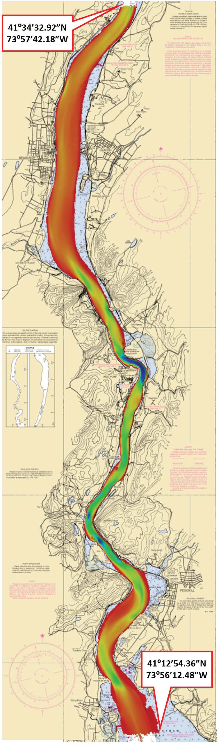
Federal
H13022: NOS Hydrographic Survey , 2017-08-09
National Oceanic and Atmospheric Administration, Department of Commerce —
The National Oceanic and Atmospheric Administration (NOAA) has the statutory mandate to collect hydrographic data in support of nautical chart compilation for safe... -
Federal
TIGER/Line Shapefile, 2021, County, Wayne County, NY, All Roads
U.S. Census Bureau, Department of Commerce —
The TIGER/Line shapefiles and related database files (.dbf) are an extract of selected geographic and cartographic information from the U.S. Census Bureau's Master... -
Federal
TIGER/Line Shapefile, 2021, County, Chenango County, NY, All Roads
U.S. Census Bureau, Department of Commerce —
The TIGER/Line shapefiles and related database files (.dbf) are an extract of selected geographic and cartographic information from the U.S. Census Bureau's Master... -
Federal
TIGER/Line Shapefile, 2021, County, Tompkins County, NY, All Roads
U.S. Census Bureau, Department of Commerce —
The TIGER/Line shapefiles and related database files (.dbf) are an extract of selected geographic and cartographic information from the U.S. Census Bureau's Master...

Official websites use .gov
A
.gov website belongs to an official government
organization in the United States.
Secure .gov websites use HTTPS
A
lock (
) or https:// means you’ve safely connected to
the .gov website. Share sensitive information only on official,
secure websites.