
-
Federal
H13611: NOS Hydrographic Survey , 2022-08-15
National Oceanic and Atmospheric Administration, Department of Commerce —
The National Oceanic and Atmospheric Administration (NOAA) has the statutory mandate to collect hydrographic data in support of nautical chart compilation for safe... -
Federal
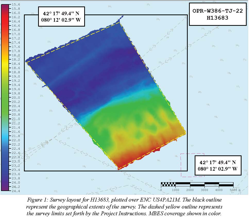
H13683: NOS Hydrographic Survey , 2022-08-14
National Oceanic and Atmospheric Administration, Department of Commerce —
The National Oceanic and Atmospheric Administration (NOAA) has the statutory mandate to collect hydrographic data in support of nautical chart compilation for safe... -
Federal
F00504: NOS Hydrographic Survey , Delaware Bay, Pennsylvania, 2004-12-07
National Oceanic and Atmospheric Administration, Department of Commerce —
The National Oceanic and Atmospheric Administration (NOAA) has the statutory mandate to collect hydrographic data in support of nautical chart compilation for safe... -
Federal
BLM Natl MLRS Non-Energy Leasables
Department of the Interior —
This dataset contains non-energy leasable cases derived from Legal Land Descriptions (LLD) contained in the US Bureau of Land Management's, BLM, Mineral and Land... -
Federal
Shoreline Mapping Program of PORTS OF PHILADELPHIA AND CAMDEN-GLOUCESTER, PA-NJ, PA0901 NGDA
National Oceanic and Atmospheric Administration, Department of Commerce —
These data provide an accurate high-resolution shoreline compiled from imagery of PORTS OF PHILADELPHIA AND CAMDEN-GLOUCESTER, PA-NJ . This vector shoreline data is... -
Federal
Shoreline Mapping Program of PORTS OF MARCUS HOOK AND CHESTER, PA AND PAULSBORO, NJ, PA0902 NGDA
National Oceanic and Atmospheric Administration, Department of Commerce —
These data provide an accurate high-resolution shoreline compiled from imagery of PORTS OF MARCUS HOOK AND CHESTER, PA AND PAULSBORO, NJ . This vector shoreline data... -
Federal
Shoreline Data Rescue Project of Schuykill River, PA, EC7D08 NGDA
National Oceanic and Atmospheric Administration, Department of Commerce —
These data were automated to provide an accurate high-resolution historical shoreline of Schuykill River, PA suitable as a geographic information system (GIS) data... -
Federal
BLM ES Administrative Unit Office Points NGDA
Department of the Interior —
This feature-dataset depicts Bureau of Land Management (BLM) office locations. The land areas for higher level administrative units (district and administrative... -
Federal
Coastal Change Analysis Program (C-CAP) Regional Land Cover Data and Change Data NGDA
National Oceanic and Atmospheric Administration, Department of Commerce —
The NOAA Coastal Change Analysis Program (C-CAP) produces national standardized land cover and change products for the coastal regions of the U.S. C-CAP products... -
Federal
Extreme Water Levels from CO-OPS
National Oceanic and Atmospheric Administration, Department of Commerce —
Extremely high or low water levels at coastal locations are an important public concern and a factor in coastal hazard assessment, navigational safety, and ecosystem... -
Federal
BLM Natl MLRS Locatable Notices
Department of the Interior —
This dataset contains notice level operations for locatable mineral cases derived from Legal Land Descriptions (LLD) contained in the US Bureau of Land Management's,... -
Federal
BLM Natl MLRS Mining Claims -Closed
Department of the Interior —
This dataset contains mining claim cases with the case disposition (status) of closed from US Bureau of Land Management's, BLM, Mineral and Land Record System(MLRS).... -
Federal
US EPA Nonattainment Areas and Designations - Download Package
U.S. Environmental Protection Agency —
This downloadable data package contains the following state level layers: Ozone 8-hr (1997 standard), Ozone 8-hr (2008 standard), Lead (2008 standard), SO2 1-hr (2010... -
Federal
TIGER 2010 Boundaries
U.S. Environmental Protection Agency —
This EnviroAtlas web service supports research and online mapping activities related to EnviroAtlas (https://www.epa.gov/enviroatlas). This web service includes the... -
Federal
H00141: NOS Hydrographic Survey , 1843-11-28
National Oceanic and Atmospheric Administration, Department of Commerce —
The National Oceanic and Atmospheric Administration (NOAA) has the statutory mandate to collect hydrographic data in support of nautical chart compilation for safe... -
Federal
H00145: NOS Hydrographic Survey , 1844-04-12
National Oceanic and Atmospheric Administration, Department of Commerce —
The National Oceanic and Atmospheric Administration (NOAA) has the statutory mandate to collect hydrographic data in support of nautical chart compilation for safe... -
Federal
H12150: NOS Hydrographic Survey , Delaware River, Pennsylvania and New Jersey, 2009-12-09
National Oceanic and Atmospheric Administration, Department of Commerce —
The National Oceanic and Atmospheric Administration (NOAA) has the statutory mandate to collect hydrographic data in support of nautical chart compilation for safe...

Official websites use .gov
A
.gov website belongs to an official government
organization in the United States.
Secure .gov websites use HTTPS
A
lock (
) or https:// means you’ve safely connected to
the .gov website. Share sensitive information only on official,
secure websites.
.jpg)
.jpg)