
-
Federal
Long Island Sound 2016 RESOURCE MANAGEMENT
National Oceanic and Atmospheric Administration, Department of Commerce —
These feature classes reside within the SOCECON Feature Data Set of the Long Island Sound 2016 ESI Geodatabase. They contain vector points and polygons representing... -
Federal
Shoreline Data Rescue Project of Long Island Sound - Point O Woods to Guardhouse Point, Connecticut, PH142B NGDA
National Oceanic and Atmospheric Administration, Department of Commerce —
These data were automated to provide an accurate high-resolution historical shoreline of Long Island Sound - Point O Woods to Guardhouse Point, Connecticut suitable... -
Federal
Vessel Logbook Database
National Oceanic and Atmospheric Administration, Department of Commerce —
This database contains the primary data reported on the vessel trip reports by vessel operators. -
Federal
Digital Bedrock Geologic-GIS Map of Weir Farm National Historical Park and Vicinity, Connecticut (NPS, GRD, GRI, WEFA, WEFA_bedrock digital map) adapted from a Connecticut Geological and Natural History Survey Connecticut Natural Resources Atlas Series map by Rodgers (1985) and a Quadrangle Report map by Kroll (1969)
Department of the Interior —
The Digital Bedrock Geologic-GIS Map of Weir Farm National Historical Park and Vicinity, Connecticut is composed of GIS data layers and GIS tables, and is available... -
Federal
H01698B: NOS Hydrographic Survey
National Oceanic and Atmospheric Administration, Department of Commerce —
The National Oceanic and Atmospheric Administration (NOAA) has the statutory mandate to collect hydrographic data in support of nautical chart compilation for safe... -
Federal
H01732: NOS Hydrographic Survey
National Oceanic and Atmospheric Administration, Department of Commerce —
The National Oceanic and Atmospheric Administration (NOAA) has the statutory mandate to collect hydrographic data in support of nautical chart compilation for safe... -
Federal
H06443: NOS Hydrographic Survey , 1939-12-31
National Oceanic and Atmospheric Administration, Department of Commerce —
The National Oceanic and Atmospheric Administration (NOAA) has the statutory mandate to collect hydrographic data in support of nautical chart compilation for safe... -
Federal
H12485: NOS Hydrographic Survey , Eastern Long Island Sound, 2013-05-13
National Oceanic and Atmospheric Administration, Department of Commerce —
The National Oceanic and Atmospheric Administration (NOAA) has the statutory mandate to collect hydrographic data in support of nautical chart compilation for safe... -
Federal
2020 Cartographic Boundary File (SHP), Current State Legislative District-Upper Chamber for Connecticut, 1:500,000
U.S. Census Bureau, Department of Commerce —
The 2020 cartographic boundary shapefiles are simplified representations of selected geographic areas from the U.S. Census Bureau's Master Address File /... -
Federal
2020 Cartographic Boundary File (KML), Current Census Tract for Connecticut, 1:500,000
U.S. Census Bureau, Department of Commerce —
The 2020 cartographic boundary KMLs are simplified representations of selected geographic areas from the U.S. Census Bureau's Master Address File / Topologically... -
Federal
Estuarine Living Marine Resources: Mid-Atlantic Regional Distribution and Abundance (NCEI Accession 0162403)
National Oceanic and Atmospheric Administration, Department of Commerce —
This is the Mid-Atlantic regional component of NOAAâs Estuarine Living Marine Resources (ELMR) Project, a national database of ecologically and economically... -
Federal
2020 Cartographic Boundary File (KML), Current State Legislative District-Upper Chamber for Connecticut, 1:500,000
U.S. Census Bureau, Department of Commerce —
The 2020 cartographic boundary KMLs are simplified representations of selected geographic areas from the U.S. Census Bureau's Master Address File / Topologically... -
Federal
2022 Cartographic Boundary File (SHP), Current Place for Connecticut, 1:500,000
U.S. Census Bureau, Department of Commerce —
The 2022 cartographic boundary shapefiles are simplified representations of selected geographic areas from the U.S. Census Bureau's Master Address File /... -
Federal
H02473: NOS Hydrographic Survey
National Oceanic and Atmospheric Administration, Department of Commerce —
The National Oceanic and Atmospheric Administration (NOAA) has the statutory mandate to collect hydrographic data in support of nautical chart compilation for safe... -
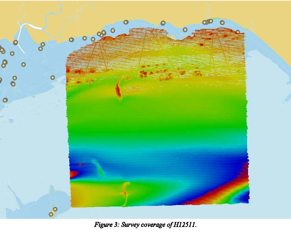
Federal
H12511: NOS Hydrographic Survey , 2020-11-19
National Oceanic and Atmospheric Administration, Department of Commerce —
The National Oceanic and Atmospheric Administration (NOAA) has the statutory mandate to collect hydrographic data in support of nautical chart compilation for safe... -
Federal
Shoreline Mapping Program of LONG ISLAND SOUND, HATCHETT POINT TO POINT JUDITH, CT, CT0401C NGDA
National Oceanic and Atmospheric Administration, Department of Commerce —
These data provide an accurate high-resolution shoreline compiled from imagery of LONG ISLAND SOUND, HATCHETT POINT TO POINT JUDITH, CT . This vector shoreline data... -
Federal
NOAA's Estuarine Living Marine Resources (ELMR) Data Base
National Oceanic and Atmospheric Administration, Department of Commerce —
In 1985, NOAA launched the Estuarine Living Marine Resources (ELMR) Program to develop a consistent data base on the distribution, relative abundance, and life... -
Federal
NOAA TIFF Image - LIS_2014_Biogeo_Backscatter_1m.tif - Benthic Habitat Characterization - Biogeographic Branch - (2014), UTM 18N NAD83
National Oceanic and Atmospheric Administration, Department of Commerce —
This dataset contains a unified backscatter GeoTiff with 1x1 meter cell size representing the 2014 Long Island Sound Benthic Habitat Priority Area of Interest off of...

Official websites use .gov
A
.gov website belongs to an official government
organization in the United States.
Secure .gov websites use HTTPS
A
lock (
) or https:// means you’ve safely connected to
the .gov website. Share sensitive information only on official,
secure websites.