
-
Federal
Tides and Currents Map: an interactive map of all CO-OPS stations NGDA 27 recent views
National Oceanic and Atmospheric Administration, Department of Commerce —
This interactive map has many features designed to provide a quick and easy way to find a Center for Operational Oceanographic Products and Services (CO-OPS) station.... -
Federal
H13614: NOS Hydrographic Survey , 2022-10-03
National Oceanic and Atmospheric Administration, Department of Commerce —
The National Oceanic and Atmospheric Administration (NOAA) has the statutory mandate to collect hydrographic data in support of nautical chart compilation for safe... -
Federal
NOAA/WDS Paleoclimatology - Wiles - Secrest Dawn Redwood - MEGL - ITRDB OH021
National Oceanic and Atmospheric Administration, Department of Commerce —
This archived Paleoclimatology Study is available from the NOAA National Centers for Environmental Information (NCEI), under the World Data Service (WDS) for... -
Federal
Meteorological Data (including visibility)
National Oceanic and Atmospheric Administration, Department of Commerce —
The National Ocean Service (NOS) maintains a long-term database containing data from active and historic stations installed all over the United States and U.S.... -
Federal
GL_LAKE_ERIE_2022 ESI INVERT Polygons
National Oceanic and Atmospheric Administration, Department of Commerce —
These feature classes reside within the BIOLOGY Feature Data Set of the Lake Erie - 2022 ESI Geodatabase. It contains vector polygons representing invertebrate data... -
Federal
GL_LAKE_ERIE_2022 ESI HYDRO Polygons, Lines
National Oceanic and Atmospheric Administration, Department of Commerce —
The feature classes HYDROL and HYDROP contain vector lines and polygons representing the coastal shoreline and hydrography used in the creation of the Environmental... -
Federal
NOAA/WDS Paleoclimatology - Wiles - Secrest Oaks - QUAL - ITRDB OH023
National Oceanic and Atmospheric Administration, Department of Commerce —
This archived Paleoclimatology Study is available from the NOAA National Centers for Environmental Information (NCEI), under the World Data Service (WDS) for... -
Federal
NOAA/WDS Paleoclimatology - Wiles - Secrest European Larch - LADE - ITRDB OH019
National Oceanic and Atmospheric Administration, Department of Commerce —
This archived Paleoclimatology Study is available from the NOAA National Centers for Environmental Information (NCEI), under the World Data Service (WDS) for... -
Federal
NOAA/WDS Paleoclimatology - Wiles - Secrest Dahurian Larch - LAGM - ITRDB OH020
National Oceanic and Atmospheric Administration, Department of Commerce —
This archived Paleoclimatology Study is available from the NOAA National Centers for Environmental Information (NCEI), under the World Data Service (WDS) for... -
Federal
NOAA/WDS Paleoclimatology - Cook - Andrew Johnson Woods - QUAL - ITRDB OH001
National Oceanic and Atmospheric Administration, Department of Commerce —
This archived Paleoclimatology Study is available from the NOAA National Centers for Environmental Information (NCEI), under the World Data Service (WDS) for... -
Federal
NOAA/WDS Paleoclimatology - Global Lake-Level Variations from 18,000 to 0 Years Ago: A Paleoclimatic Analysis
National Oceanic and Atmospheric Administration, Department of Commerce —
This archived Paleoclimatology Study is available from the NOAA National Centers for Environmental Information (NCEI), under the World Data Service (WDS) for... -
Federal
H13612: NOS Hydrographic Survey , 2022-06-14
National Oceanic and Atmospheric Administration, Department of Commerce —
The National Oceanic and Atmospheric Administration (NOAA) has the statutory mandate to collect hydrographic data in support of nautical chart compilation for safe... -
Federal
Gravity Data For The State of Ohio
National Oceanic and Atmospheric Administration, Department of Commerce —
The gravity station data (6,591 records) were compiled by the U. S. Geological Survey. This data base was received on February 23, 1993. Principal gravity parameters... -
Federal
GL_LAKE_ERIE_2022 ESI BENTHIC Polygons
National Oceanic and Atmospheric Administration, Department of Commerce —
This feature class resides within the BIOLOGY Feature Data Set of the Lake Erie - 2022 ESI Geodatabase. It contains vector polygons representing BENTHIC data for Lake... -
Federal
NOAA/WDS Paleoclimatology - Wiles - Wooster Memorial Park Oaks - QUAL - ITRDB OH024
National Oceanic and Atmospheric Administration, Department of Commerce —
This archived Paleoclimatology Study is available from the NOAA National Centers for Environmental Information (NCEI), under the World Data Service (WDS) for... -
Federal
NOAA/WDS Paleoclimatology - Maxwell - Hueston Woods - FAGR - ITRDB OH013
National Oceanic and Atmospheric Administration, Department of Commerce —
This archived Paleoclimatology Study is available from the NOAA National Centers for Environmental Information (NCEI), under the World Data Service (WDS) for... -
Federal
NOAA/WDS Paleoclimatology - Maxwell - Clear Fork Gorge - PIST - ITRDB OH008
National Oceanic and Atmospheric Administration, Department of Commerce —
This archived Paleoclimatology Study is available from the NOAA National Centers for Environmental Information (NCEI), under the World Data Service (WDS) for... -
Federal
Coastal Change Analysis Program (C-CAP) Regional Land Cover Data and Change Data NGDA
National Oceanic and Atmospheric Administration, Department of Commerce —
The NOAA Coastal Change Analysis Program (C-CAP) produces national standardized land cover and change products for the coastal regions of the U.S. C-CAP products... -
Federal
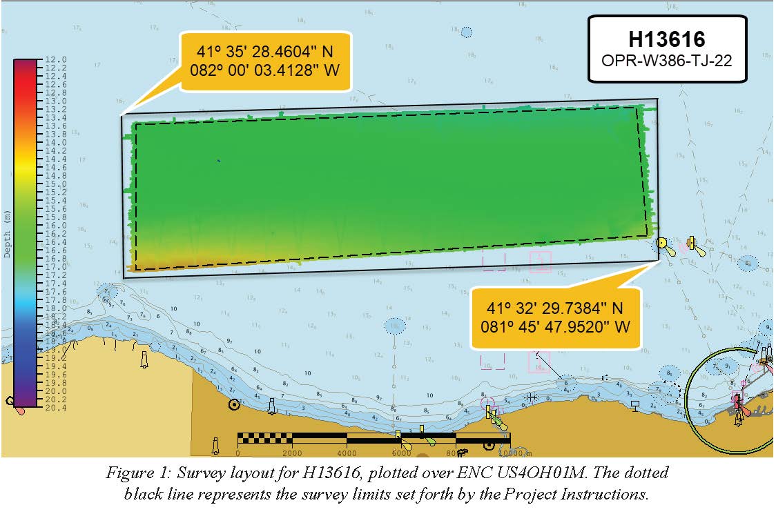
H13616: NOS Hydrographic Survey , 2022-06-21
National Oceanic and Atmospheric Administration, Department of Commerce —
The National Oceanic and Atmospheric Administration (NOAA) has the statutory mandate to collect hydrographic data in support of nautical chart compilation for safe... -
Federal
H13607: NOS Hydrographic Survey , 2022-08-18
National Oceanic and Atmospheric Administration, Department of Commerce —
The National Oceanic and Atmospheric Administration (NOAA) has the statutory mandate to collect hydrographic data in support of nautical chart compilation for safe...

Official websites use .gov
A
.gov website belongs to an official government
organization in the United States.
Secure .gov websites use HTTPS
A
lock (
) or https:// means you’ve safely connected to
the .gov website. Share sensitive information only on official,
secure websites.