
-
Federal
Shoreline Data Rescue Project of Sand Island to Oceanside, WA, WC44C01 NGDA
National Oceanic and Atmospheric Administration, Department of Commerce —
These data were automated to provide an accurate high-resolution historical shoreline of Sand Island to Oceanside, WA suitable as a geographic information system... -
Federal
Shoreline Data Rescue Project of Everett, Washington, PH147 NGDA
National Oceanic and Atmospheric Administration, Department of Commerce —
These data were automated to provide an accurate high-resolution historical shoreline of Everett, Washington suitable as a geographic information system (GIS) data... -
Federal
Shoreline Data Rescue Project of Fidalgo Island, WA, WA1927D NGDA
National Oceanic and Atmospheric Administration, Department of Commerce —
These data were automated to provide an accurate high-resolution historical shoreline of Fidalgo Island, WA suitable as a geographic information system (GIS) data... -
Federal
Shoreline Mapping Program of Ports of Longview and Kalama, WA, WA1804-CS-N NGDA
National Oceanic and Atmospheric Administration, Department of Commerce —
These data provide an accurate high-resolution shoreline compiled from imagery of Ports of Longview and Kalama, WA . This vector shoreline data is based on an office... -
Federal
Shoreline Data Rescue Project of Haro Strait, WA, WA1942B NGDA
National Oceanic and Atmospheric Administration, Department of Commerce —
These data were automated to provide an accurate high-resolution historical shoreline of Haro Strait, WA suitable as a geographic information system (GIS) data layer.... -
Federal
Shoreline Data Rescue Project of Elliot Bay, Washington, PH6712 NGDA
National Oceanic and Atmospheric Administration, Department of Commerce —
These data were automated to provide an accurate high-resolution historical shoreline of Elliot Bay, Washington suitable as a geographic information system (GIS) data... -
Federal
Shoreline Mapping Program of PORTS OF BREMERTON AND MANCHESTER, WA, WA0702 NGDA
National Oceanic and Atmospheric Administration, Department of Commerce —
These data provide an accurate high-resolution shoreline compiled from imagery of PORTS OF BREMERTON AND MANCHESTER, WA . This vector shoreline data is based on an... -
Federal
Shoreline Data Rescue Project of Morse Creek to Dungeness, WA, WC47A02 NGDA
National Oceanic and Atmospheric Administration, Department of Commerce —
These data were automated to provide an accurate high-resolution historical shoreline of Morse Creek to Dungeness, WA suitable as a geographic information system... -
Federal
Shoreline Data Rescue Project of Puget Sound, WA, WC48C06 NGDA
National Oceanic and Atmospheric Administration, Department of Commerce —
These data were automated to provide an accurate high-resolution historical shoreline of Puget Sound, WA suitable as a geographic information system (GIS) data layer.... -
Federal
NOAA Office for Coastal Management Coastal Inundation Digital Elevation Model: Seattle (WA) WFO - Clallam, Jefferson, Kitsap, Mason, Pierce, and Thurston Counties
National Oceanic and Atmospheric Administration, Department of Commerce —
This digital elevation model (DEM) is a part of a series of DEMs produced for the National Oceanic and Atmospheric Administration Office for Coastal Management's Sea... -
Federal
NOAA/WDS Paleoclimatology - Graumlich - Wynoochee Falls - TSME - ITRDB WA058
National Oceanic and Atmospheric Administration, Department of Commerce —
This archived Paleoclimatology Study is available from the NOAA National Centers for Environmental Information (NCEI), under the World Data Service (WDS) for... -
Federal
NOAA/WDS Paleoclimatology - Peterson - Klahhane Ridge Medium - ABLA - ITRDB WA123
National Oceanic and Atmospheric Administration, Department of Commerce —
This archived Paleoclimatology Study is available from the NOAA National Centers for Environmental Information (NCEI), under the World Data Service (WDS) for... -
Federal
Regional Hydrodynamic Model Outputs of the NOAA Columbia River Estuary Operational Forecast System (CREOFS)
National Oceanic and Atmospheric Administration, Department of Commerce —
NOAA's National Ocean Service (NOS) has developed a Columbia River Estuary Operational Forecast System (CREOFS). CREOFS is based on a three-dimensional SELFE model... -
Federal
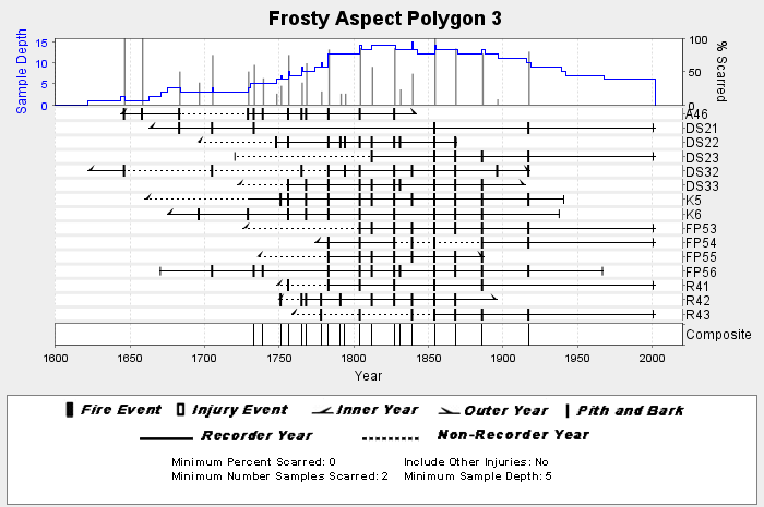
NOAA/WDS Paleoclimatology - Everett fire data from Frosty Aspect Polygon 3 - IMPD USFRS003
National Oceanic and Atmospheric Administration, Department of Commerce —
This archived Paleoclimatology Study is available from the NOAA National Centers for Environmental Information (NCEI), under the World Data Service (WDS) for... -
Federal
NOAA/WDS Paleoclimatology - Marcinkowski - Easy Pass - TSME - ITRDB WA144
National Oceanic and Atmospheric Administration, Department of Commerce —
This archived Paleoclimatology Study is available from the NOAA National Centers for Environmental Information (NCEI), under the World Data Service (WDS) for... -
Federal
NOAA/WDS Paleoclimatology - Ferguson - Boulder Creek Washington Winthrop - PIPO - ITRDB WA043
National Oceanic and Atmospheric Administration, Department of Commerce —
This archived Paleoclimatology Study is available from the NOAA National Centers for Environmental Information (NCEI), under the World Data Service (WDS) for... -
Federal
NOAA/WDS Paleoclimatology - Everett fire data from Twenty Mile Aspect Polygon 4 - IMPD USTWM004
National Oceanic and Atmospheric Administration, Department of Commerce —
This archived Paleoclimatology Study is available from the NOAA National Centers for Environmental Information (NCEI), under the World Data Service (WDS) for... -
Federal
NOAA/WDS Paleoclimatology - Brubaker - Windy Meadows - PIPO - ITRDB WA014
National Oceanic and Atmospheric Administration, Department of Commerce —
This archived Paleoclimatology Study is available from the NOAA National Centers for Environmental Information (NCEI), under the World Data Service (WDS) for... -
Federal
NOAA/WDS Paleoclimatology - Peterson - Blue Mountain Medium - ABLA - ITRDB WA126
National Oceanic and Atmospheric Administration, Department of Commerce —
This archived Paleoclimatology Study is available from the NOAA National Centers for Environmental Information (NCEI), under the World Data Service (WDS) for... -
Federal
NOAA/WDS Paleoclimatology - Everett fire data from Twenty Mile Aspect Polygon 8 - IMPD USTWM008
National Oceanic and Atmospheric Administration, Department of Commerce —
This archived Paleoclimatology Study is available from the NOAA National Centers for Environmental Information (NCEI), under the World Data Service (WDS) for...

Official websites use .gov
A
.gov website belongs to an official government
organization in the United States.
Secure .gov websites use HTTPS
A
lock (
) or https:// means you’ve safely connected to
the .gov website. Share sensitive information only on official,
secure websites.