

22 datasets found
-
Federal
West Flank Coso FORGE: Downhole Lithologic Data
Department of Energy —
x,y,z downhole lithologic logs for the wells in and around the West Flank FORGE site based on a review of cuttings, core, and mud logs. -
Federal
West Flank Coso FORGE: Geologic Cross-Sections
Department of Energy —
Geologic cross sections from the West Flank FORGE site. Cross Section traces linked in resources. -
Federal
West Flank Coso FORGE: Magnetotelluric 3D Data
Department of Energy —
This is the 3D version of the MT data for the West Flank Coso FORGE area. The Coso geothermal field has had three Magnetotelluric (MT) datasets collected including... -
Federal
West Flank Coso FORGE: ArcGIS Data for Geologic Model
Department of Energy —
Archive of ArcGIS data from the West Flank FORGE site located in Coso, California. Archive contains the following eight shapefiles: Polygon of the 3D geologic model... -
Federal
Envisat Track 349 and Sentinel-1A Track 64 Interferometric Synthetic Aperture Radar Data of Coso Geothermal Field, California, USA, 2004-2016
Department of Energy —
This submission contains tarred pair directories for interferometric synthetic aperture radar (InSAR) data covering Coso Geothermal Field in California, USA.... -
Federal
West Flank Coso Downhole Temperature Data
Department of Energy —
Downhole temperature data for the three wells inside the West Flank FORGE footprint; 83-11, TCH 74-2 and TCH 48-11. TCH 74-2 and TCH 48-11 were both collected before... -
Federal
DEEPEN Data Catalog for Magmatic Geothermal Systems in the United States
Department of Energy —
This data catalog contains information related to the Training Site Analysis for the Geothermica project "DE-risking Exploration of geothermal Plays in magmatic... -
Federal
West Flank Coso FORGE: 3D Temperature Model
Department of Energy —
x,y,z data of the 3D temperature model for the West Flank Coso FORGE site. Model grid spacing is 250m. The temperature model for the Coso geothermal field used over... -
Federal
West Flank Coso FORGE: Refined Earthquake Focal Mechanism Catalog for Southern California (1981-2010)
Department of Energy —
A refined earthquake mechanism catalog for southern Califiornia using the HASH method and locations derived from waveform cross-correlation. Each focal mechanism is... -
Federal
COSO Fluid Inclusion Gas Analysis
Department of Energy —
Fluid inclusion gas analysis for wells in COSO geothermal area, California. Analyses used in developing fluid inclusion stratigraphy for wells and defining fluids... -
Federal
West Flank Coso FORGE: Well Photos and Notes
Department of Energy —
Photos and detailed downhole lithology notes for wells CGEH-1 and 74-2 at the West Flank Coso, Ca FORGE location. -
Federal
West Flank Coso FORGE: MT Station Locations
Department of Energy —
This data includes the locations of the MT data collected in and around the Coso Geothermal field that covered the West Flank area. These are the data that the 3D MT... -
Federal
West Flank Coso FORGE: 33-7 Image Log
Department of Energy —
EMI (Electric Micro Imaging tool, Halliburton) image log in GMI Imager format. GMI Imager is software available from Baker Hughes and is used to open .img files. -
Federal
West Flank Coso FORGE: 52B-7 Image and Mud Log
Department of Energy —
FMI image log and mud log of well 52B-7 -
Federal
West Flank Coso FORGE: 83-11 Image and Mud Log Data
Department of Energy —
CBIL and STAR image logs as pre-processed DLIS files, and mud log of well 83-11 -
Federal
West Flank Coso FORGE Digital Elevation Model and Geology Shapefiles
Department of Energy —
Geologic ArcGIS data of West Flank Coso, Ca FORGE site from a unpublished map by Rich Whitmarsh. The zip file includes a DEM, hillshade and four shapefiles of the... -
Federal
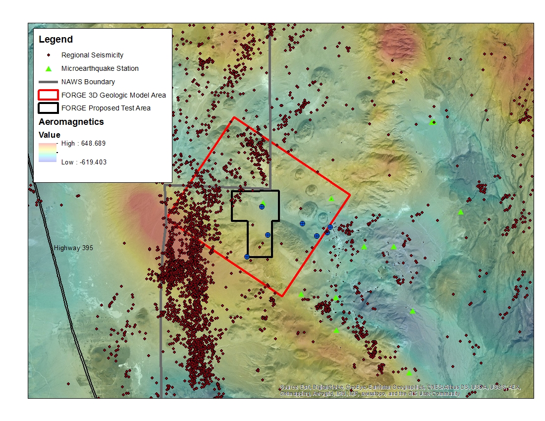
West Flank Coso, CA FORGE Test Area
Department of Energy —
A map with the Coso West Flank FORGE test area outlined, along with regional seismicity, the aeromagnetic data set and the area currently being utilized for the... -
Federal
West Flank Coso FORGE: Indian Wells Valley Aeromagnetic Data
Department of Energy —
Aeromagnetic data was collected over the Indian Wells Valley, CA in November 1994. It consisted of 9,033 line-kilometers covering ~4,150 square kilometers, flown at a... -
Federal
West Flank Coso FORGE: 3D Geologic Model
Department of Energy —
This is an x,y,z file of the West Flank FORGE 3D geologic model. Model created in Earthvision by Dynamic Graphic Inc. The model was constructed with a grid spacing of... -
Federal
West Flank Coso FORGE: 33A-7 Image and Mud Log Data
Department of Energy —
Circumferential Borehole Imaging Log (CBIL) image log as DLIS file, and PDF mud log of well 33A-7 as part of the West Flank Coso, CA FORGE site.
22 datasets found